IMAGES TAKEN NEAR TO
Siemens Way, SWANSEA, SA7 9BB
Introduction
This page details the photographs taken nearby to Siemens Way, SA7 9BB by members of the Geograph project.
The Geograph project started in 2005 with the aim of publishing, organising and preserving representative images for every square kilometre of Great Britain, Ireland and the Isle of Man.

There are currently over 7.5m images from over14,400 individuals and you can help contribute to the project by visiting https://www.geograph.org.uk
Image Map
Images are licensed for reuse under creativecommons.org/licenses/by-sa/2.0
Notes
- Clicking on the map will re-center to the selected point.
- The higher the marker number, the further away the image location is from the centre of the postcode.
Image Listing (9 Images Found)
Images are licensed for reuse under creativecommons.org/licenses/by-sa/2.0
Image
Details
Distance
1
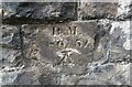
Benchmark on Railway Bridge
This tiny Benchmark can be found on the SW buttress of the railway bridge on Nantong Way.
Image: © Adrian Dust
Taken: 21 Sep 2021
0.15 miles
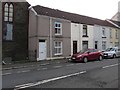
2
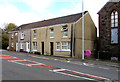
Row of four houses, Neath Road, Plasmarl, Swansea
A derelict former chapel https://www.geograph.org.uk/photo/5988918 is on the right.
Image: © Jaggery
Taken: 12 Nov 2018
0.24 miles
3
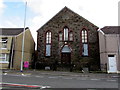
Former Ebenezer Methodist chapel, Neath Road, Plasmarl, Swansea
Derelict building viewed in November 2018. The name tablet https://www.geograph.org.uk/photo/5988919 shows
EBENEZER PRIMITIVE METHODIST CHAPEL 1885.
Image: © Jaggery
Taken: 12 Nov 2018
0.24 miles
4
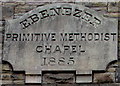
Year tablet on the former Ebenezer Methodist chapel, Neath Road, Plasmarl, Swansea
The tablet on this https://www.geograph.org.uk/photo/5988918 building shows
EBENEZER PRIMITIVE METHODIST CHAPEL 1885.
Image: © Jaggery
Taken: 12 Nov 2018
0.24 miles
5
Mannesman Corner electricity substation, Neath Road, Swansea
The Western Power Distribution electricity substation identifier is
MANNESMAN CORNER MORRISTON S/S 521840
Image: © Jaggery
Taken: 12 Nov 2018
0.24 miles
6
High numbers near a former chapel, Neath Road, Plasmarl, Swansea
Row of houses on the southwest side of this https://www.geograph.org.uk/photo/5988918 derelict former chapel.
The house on the left is number 1121 Neath Road.
Image: © Jaggery
Taken: 12 Nov 2018
0.24 miles
7
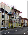
Scaffolding on 1126 Neath Road, Plasmarl, Swansea
Three-storey block of twelve flats under scaffolding on November 12th 2018.
Image: © Jaggery
Taken: 12 Nov 2018
0.24 miles
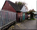
8
Plasmarl Community Centre direction sign, Swansea
The sign facing the B4603 Neath Road points towards this https://www.geograph.org.uk/photo/5988927 blue building.
The text is also in Welsh.
Image: © Jaggery
Taken: 12 Nov 2018
0.25 miles
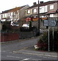
9
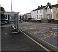
Neath Road bus stop and shelter, Plasmarl, Swansea
This stop near Dinas Street is for buses to the city centre and Swansea bus station.
Image: © Jaggery
Taken: 12 Nov 2018
0.25 miles