IMAGES TAKEN NEAR TO
Lower Thornton, MILFORD HAVEN, SA73 3UH
Introduction
This page details the photographs taken nearby to SA73 3UH by members of the Geograph project.
The Geograph project started in 2005 with the aim of publishing, organising and preserving representative images for every square kilometre of Great Britain, Ireland and the Isle of Man.

There are currently over 7.5m images from over14,400 individuals and you can help contribute to the project by visiting https://www.geograph.org.uk
Image Map (Loading...)


Getting Data...Please wait
Leaflet Map data © OpenStreetMap
Images are licensed for reuse under creativecommons.org/licenses/by-sa/2.0
Notes
- Clicking on the map will re-center to the selected point.
- The higher the marker number, the further away the image location is from the centre of the postcode.
Image Listing (3 Images Found)
Images are licensed for reuse under creativecommons.org/licenses/by-sa/2.0
Image
Details
Distance
2
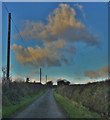
Lane Between Thornton And Tiers Cross
Drivers beware! Narrow with very few passing places!
Image: © Deborah Tilley
Taken: 15 Jan 2016
0.11 miles
3
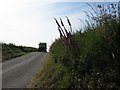
Approaching tractor
The farmers were still hard at it at 6pm on a Saturday, shifting loads from the field behind me to the farm at Tierson.
Image: © Colin Bell
Taken: 14 Jun 2008
0.23 miles