IMAGES TAKEN NEAR TO
Dale Road, MILFORD HAVEN, SA73 3RX
Introduction
This page details the photographs taken nearby to Dale Road, SA73 3RX by members of the Geograph project.
The Geograph project started in 2005 with the aim of publishing, organising and preserving representative images for every square kilometre of Great Britain, Ireland and the Isle of Man.

There are currently over 7.5m images from over14,400 individuals and you can help contribute to the project by visiting https://www.geograph.org.uk
Image Map (Loading...)


Getting Data...Please wait
Leaflet Map data © OpenStreetMap
Images are licensed for reuse under creativecommons.org/licenses/by-sa/2.0
Notes
- Clicking on the map will re-center to the selected point.
- The higher the marker number, the further away the image location is from the centre of the postcode.
Image Listing (3 Images Found)
Images are licensed for reuse under creativecommons.org/licenses/by-sa/2.0
Image
Details
Distance
1
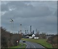
Lodge Farm
Between Herbranston and Hubberston
Image: © Deborah Tilley
Taken: 12 Feb 2016
0.06 miles
2
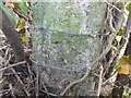
Ordnance Survey Cut Mark
This badly eroded OS cut mark can be found on the concrete gatepost south side of the road. It marks a point 59.448m above mean sea level.
Image: © Adrian Dust
Taken: 28 Mar 2022
0.18 miles
3
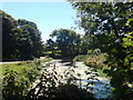
Pond at St Botolphs
It was a muddy pool just a few years ago but was restored to its former glory by Ralph Beer, owner of St Botolphs before he died.
Image: © Deborah Tilley
Taken: 21 Jul 2008
0.23 miles