IMAGES TAKEN NEAR TO
St. Lawrence Hill, MILFORD HAVEN, SA73 3PG
Introduction
This page details the photographs taken nearby to St. Lawrence Hill, SA73 3PG by members of the Geograph project.
The Geograph project started in 2005 with the aim of publishing, organising and preserving representative images for every square kilometre of Great Britain, Ireland and the Isle of Man.

There are currently over 7.5m images from over14,400 individuals and you can help contribute to the project by visiting https://www.geograph.org.uk
Image Map
Images are licensed for reuse under creativecommons.org/licenses/by-sa/2.0
Notes
- Clicking on the map will re-center to the selected point.
- The higher the marker number, the further away the image location is from the centre of the postcode.
Image Listing (54 Images Found)
Images are licensed for reuse under creativecommons.org/licenses/by-sa/2.0
Image
Details
Distance
1
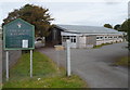
Church of the Holy Spirit, Milford Haven
The church is set back 50 metres from Waterloo Road. The name board shows that the
Church in Wales church is in the parish of Hubberston and Hakin.
The building, opened in 1971, is also used as a hall and meeting place.
Image: © Jaggery
Taken: 31 Aug 2012
0.03 miles
2
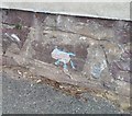
Ordnance Survey Cut Mark
This OS cut mark can be found on the wall of The Bungalow, St Lawrence Hill. It marks a point 37.144m above mean sea level.
Image: © Adrian Dust
Taken: 28 Sep 2019
0.05 miles
3
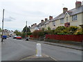
Waterloo Road, Milford Haven
Viewed from near the St Lawrence Hill junction. This is part of the Hakin area of Milford Haven.
Image: © Jaggery
Taken: 31 Aug 2012
0.07 miles
4
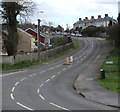
Up Waterloo Road, Milford Haven
From Dale Road, Waterloo Road ascends towards the centre of Milford Haven
Image: © Jaggery
Taken: 11 Mar 2019
0.08 miles
5
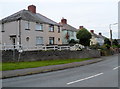
Houses on the south side of Waterloo Road, Milford Haven
This section of Waterloo Road is west of the Glebelands turning. The houses are opposite bungalows in Court Rise. A sign on the left, leaning from vertical, points right towards a church. http://www.geograph.org.uk/photo/3111333
Image: © Jaggery
Taken: 31 Aug 2012
0.09 miles
6
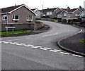
Silverstream Drive, Hakin, Milford Haven
Viewed across Camuset Close. Silverstream Drive leads to Silverstream Crescent.
Image: © Jaggery
Taken: 11 Mar 2019
0.09 miles
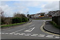
7
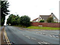
St Lawrence Hill passes Romilly Crescent, Milford Haven
Although in the middle of Milford Haven, St Lawrence Hill has a semi-rural character. There is only one house alongside the road in the 200 metre section behind the camera between a car wash http://www.geograph.org.uk/photo/3110140 and the turning for James Street. http://www.geograph.org.uk/photo/3110159
Image: © Jaggery
Taken: 31 Aug 2012
0.10 miles
8
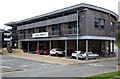
Milford Haven Library
Cedar Court, Haven's Head Business Park, Milford Haven SA73 3LS
Image: © Arthur C Harris
Taken: 18 Apr 2016
0.10 miles
9
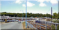
Approaching Milford Haven station from the Docks, 2004
View northward, from by Tesco Superstore. This is the terminus of passenger trains from England, via Swansea, Carmarthen and the branch from the Fishguard line at Clarbeston Road.
Image: © Ben Brooksbank
Taken: 24 Jun 2004
0.11 miles
10
Camuset Close, Hakin, Milford Haven
Viewed across the road named Silverstream. The Silverstream Drive junction is ahead on the right.
Image: © Jaggery
Taken: 11 Mar 2019
0.14 miles