IMAGES TAKEN NEAR TO
The Ropewalk, MILFORD HAVEN, SA73 3LW
Introduction
This page details the photographs taken nearby to The Ropewalk, SA73 3LW by members of the Geograph project.
The Geograph project started in 2005 with the aim of publishing, organising and preserving representative images for every square kilometre of Great Britain, Ireland and the Isle of Man.

There are currently over 7.5m images from over14,400 individuals and you can help contribute to the project by visiting https://www.geograph.org.uk
Image Map (Loading...)


Getting Data...Please wait
Leaflet Map data © OpenStreetMap
Images are licensed for reuse under creativecommons.org/licenses/by-sa/2.0
Notes
- Clicking on the map will re-center to the selected point.
- The higher the marker number, the further away the image location is from the centre of the postcode.
Image Listing (117 Images Found)
Images are licensed for reuse under creativecommons.org/licenses/by-sa/2.0
Image
Details
Distance
2
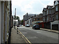
James Street, Milford Haven
Viewed from the St Lawrence Hill end. James Street is in the Hakin district of Milford Haven.
Image: © Jaggery
Taken: 31 Aug 2012
0.09 miles
3
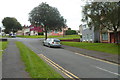
St Anne's Road, Milford Haven
St Anne's Road, elevated high above the waterfront, leads towards the Hakin district of the town.
Image: © Stephen McKay
Taken: 11 Apr 2018
0.09 miles
4
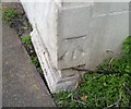
Ordnance Survey Cut Mark
This OS cut mark can be found on L & R Wines, No3 St Anne's Road. It marks a point 18.315m above mean sea level.
Image: © Adrian Dust
Taken: 28 Sep 2019
0.12 miles
5
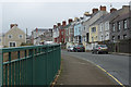
Across Milford Haven Docks
Looking west from Nelson Quay.
Image: © Jaggery
Taken: 31 Aug 2012
0.12 miles
6
Milford Haven Seal Hospital
Housed in a disused oil refinery storage tank on Discovery Quay.
Image: © Jaggery
Taken: 31 Aug 2012
0.12 miles
7
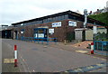
MITEC, Milford Haven
Located in The Docks, MITEC is part of Pembrokeshire College.
This is an industrial training centre, incorporating welding, plating and pipefitting.
Image: © Jaggery
Taken: 31 Aug 2012
0.12 miles
8
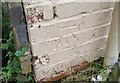
Ordnance Survey Cut Mark
This OS cut mark can be found on No1 James Street. It marks a point 19.679m above mean sea level.
Image: © Adrian Dust
Taken: 28 Sep 2019
0.12 miles
9
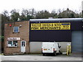
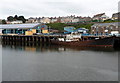
Fish merchants
There is only a small fishing industry at Milford now - and much of the catch, caught by Spanish fishermen, goes straight to Spain - but in during the first half of the C20 fishing was big business here with work on, and supporting, the trawler fleet, the main occupation for local people: once 'ever day was pay-day' it is said. Fishing stocks declined from the 60's onwards and pollution has been an on-going problem.
Image: © Natasha Ceridwen de Chroustchoff
Taken: 17 Mar 2007
0.13 miles
10
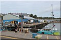
K Wall, Fish Docks, Milford Haven
Warehouses on quay.
Image: © M J Roscoe
Taken: 23 Sep 2023
0.14 miles