IMAGES TAKEN NEAR TO
Thornton Industrial Trading Estate, MILFORD HAVEN, SA73 2RX
Introduction
This page details the photographs taken nearby to Thornton Industrial Trading Estate, SA73 2RX by members of the Geograph project.
The Geograph project started in 2005 with the aim of publishing, organising and preserving representative images for every square kilometre of Great Britain, Ireland and the Isle of Man.

There are currently over 7.5m images from over14,400 individuals and you can help contribute to the project by visiting https://www.geograph.org.uk
Image Map
Images are licensed for reuse under creativecommons.org/licenses/by-sa/2.0
Notes
- Clicking on the map will re-center to the selected point.
- The higher the marker number, the further away the image location is from the centre of the postcode.
Image Listing (4 Images Found)
Images are licensed for reuse under creativecommons.org/licenses/by-sa/2.0
Image
Details
Distance
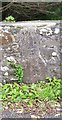
1

Child's grave, Milford Haven cemetery
Image: © Natasha Ceridwen de Chroustchoff
Taken: 17 Mar 2007
0.07 miles
2
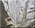
Ordnance Survey Cut Mark
This OS cut mark can be found on the cemetery lodge. It marks a point 33.097m above mean sea level.
Image: © Adrian Dust
Taken: 28 Sep 2019
0.08 miles
3

Railway south from Thornton
This single track line reaches its terminus a mile south at Milford Haven station.
Image: © Colin Bell
Taken: 14 Jun 2008
0.15 miles
4
Boundary Stone
This Boundary Stone can be found on the SW parapet of the bridge. There is an OS cut mark on it which marks a point 12.726m above mean sea level.
Image: © Adrian Dust
Taken: 28 Sep 2019
0.24 miles