IMAGES TAKEN NEAR TO
Shakespeare Avenue, MILFORD HAVEN, SA73 2JH
Introduction
This page details the photographs taken nearby to Shakespeare Avenue, SA73 2JH by members of the Geograph project.
The Geograph project started in 2005 with the aim of publishing, organising and preserving representative images for every square kilometre of Great Britain, Ireland and the Isle of Man.

There are currently over 7.5m images from over14,400 individuals and you can help contribute to the project by visiting https://www.geograph.org.uk
Image Map (Loading...)


Getting Data...Please wait
Leaflet Map data © OpenStreetMap
Images are licensed for reuse under creativecommons.org/licenses/by-sa/2.0
Notes
- Clicking on the map will re-center to the selected point.
- The higher the marker number, the further away the image location is from the centre of the postcode.
Image Listing (141 Images Found)
Images are licensed for reuse under creativecommons.org/licenses/by-sa/2.0
Image
Details
Distance
1
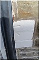
Ordnance Survey Cut Mark
This OS cut mark can be found on No32 Greville Road. It marks a point 52.095m above mean sea level.
Image: © Adrian Dust
Taken: 28 Sep 2019
0.03 miles
2
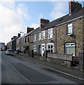
Warwick Road houses, Milford Haven
Stone houses on the north side of Warwick Road viewed from the corner of Great North Road.
Image: © Jaggery
Taken: 5 Sep 2017
0.05 miles
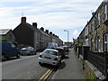
3
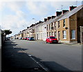
West along Robert Street, Milford Haven
From the corner of the A4076 Great North Road.
Image: © Jaggery
Taken: 5 Sep 2017
0.05 miles
4
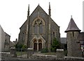
North Road Baptist Church, Milford Haven
Built in 1878,North Road Baptist Church, Milford Haven.
Image: © Arthur C Harris
Taken: 30 Sep 2014
0.05 miles
6
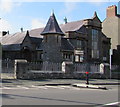
North Road Baptist Church, Milford Haven
This part of the church is the 1926-1927 schoolroom and hall on the north side
of the main building https://www.geograph.org.uk/photo/4202097 erected in 1878. Both buildings are Grade II listed.
Image: © Jaggery
Taken: 5 Sep 2017
0.07 miles
7
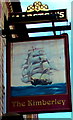
Kimberley name sign, Great North Road, Milford Haven
Hanging from a wall bracket here. http://www.geograph.org.uk/photo/997265
Image: © Jaggery
Taken: 5 Sep 2017
0.07 miles
8
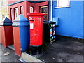
King George V pillarbox, Great North Road, Milford Haven
Alongside the A4076 Great North Road near the corner of Warwick Road.
The GR on the box is short for Georgius Rex, Latin for King George,
in this case King George V who reigned from May 1910-January 1936.
Image: © Jaggery
Taken: 5 Sep 2017
0.08 miles
9
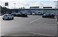
Lidl, Milford Haven
Supermarket set back 55 metres from the west side of the A4076 Great North Road.
Image: © Jaggery
Taken: 5 Sep 2017
0.09 miles
10
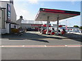
Victoria Filling Station, Milford Haven
Texaco filling station, shop and off licence on the west side of the A4076 Great North Road.
Image: © Jaggery
Taken: 5 Sep 2017
0.09 miles