IMAGES TAKEN NEAR TO
Stratford Road, MILFORD HAVEN, SA73 2JD
Introduction
This page details the photographs taken nearby to Stratford Road, SA73 2JD by members of the Geograph project.
The Geograph project started in 2005 with the aim of publishing, organising and preserving representative images for every square kilometre of Great Britain, Ireland and the Isle of Man.

There are currently over 7.5m images from over14,400 individuals and you can help contribute to the project by visiting https://www.geograph.org.uk
Image Map (Loading...)


Getting Data...Please wait
Leaflet Map data © OpenStreetMap
Images are licensed for reuse under creativecommons.org/licenses/by-sa/2.0
Notes
- Clicking on the map will re-center to the selected point.
- The higher the marker number, the further away the image location is from the centre of the postcode.
Image Listing (141 Images Found)
Images are licensed for reuse under creativecommons.org/licenses/by-sa/2.0
Image
Details
Distance
1
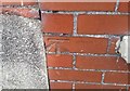
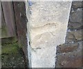
Ordnance Survey Cut Mark
This OS cut mark can be found on No37 Albion Street. It marks a point 50.648m above mean sea level.
Image: © Adrian Dust
Taken: 28 Sep 2019
0.06 miles
2
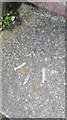
Ordnance Survey Rivet
This OS rivet can be found on the steps at the junction of Fulke Street & Roberts Street. It marks a point 43.298m above mean sea level.
Image: © Adrian Dust
Taken: 28 Sep 2019
0.09 miles
3
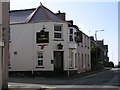
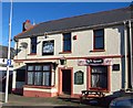
Pembrokeshire Pubs: The Victoria in Priory Road
Image: © Shaun Butler
Taken: 8 Oct 2008
0.09 miles
4
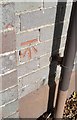
Ordnance Survey Cut Mark
This OS cut mark can be found on the south angle of the school. It marks a point 51.098m above mean sea level.
Image: © Adrian Dust
Taken: 28 Sep 2019
0.10 miles
5
Ordnance Survey Cut Mark
This damaged OS cut mark can be found on the Methodist Chapel, Priory Road. It marks a point 47.992m above mean sea level.
Image: © Adrian Dust
Taken: 28 Sep 2019
0.11 miles
6
The Trafalgar, Milford Haven
The Trafalgar,Charles Street,Milford Haven.
Image: © Arthur C Harris
Taken: 2 Oct 2014
0.12 miles
7

Repainting the Belhaven House Hotel, Milford Haven
The Hamilton Terrace hotel is being repainted in early September 2017.
The national flag of Wales and the flag of Pembrokeshire are in view.
Dating from the 1790s, this was one of the first buildings erected in Milford Haven.
It may have been the bakery set up for the Nantucket whaling fleet by Timothy Folger,
one of the leaders of the North American whalers invited to Milford in 1792.
Grade II listed in 1993.
Image: © Jaggery
Taken: 5 Sep 2017
0.12 miles
8
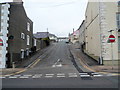
Francis Street, Milford Haven
Viewed from Hamilton Terrace. A one-way traffic system operates along Francis Street.
Image: © Jaggery
Taken: 31 Aug 2012
0.12 miles
9
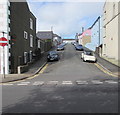
On-street parking, Francis Street, Milford Haven
One-way Francis Street ascends to Charles Street and Robert Street from the A4076 Hamilton Terrace.
Image: © Jaggery
Taken: 5 Sep 2017
0.12 miles
10
Ordnance Survey Cut Mark
This OS cut mark can be found on No32 Greville Road. It marks a point 52.095m above mean sea level.
Image: © Adrian Dust
Taken: 28 Sep 2019
0.12 miles