IMAGES TAKEN NEAR TO
Robert Street, MILFORD HAVEN, SA73 2DJ
Introduction
This page details the photographs taken nearby to Robert Street, SA73 2DJ by members of the Geograph project.
The Geograph project started in 2005 with the aim of publishing, organising and preserving representative images for every square kilometre of Great Britain, Ireland and the Isle of Man.

There are currently over 7.5m images from over14,400 individuals and you can help contribute to the project by visiting https://www.geograph.org.uk
Image Map
Images are licensed for reuse under creativecommons.org/licenses/by-sa/2.0
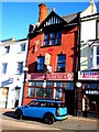
Notes
- Clicking on the map will re-center to the selected point.
- The higher the marker number, the further away the image location is from the centre of the postcode.
Image Listing (262 Images Found)
Images are licensed for reuse under creativecommons.org/licenses/by-sa/2.0
Image
Details
Distance
1
Lord Kitchener, Milford Haven
Lord Kitchener Hotel,Charles Street,Milford Haven.
Image: © Arthur C Harris
Taken: 2 Oct 2014
0.04 miles
3
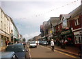
Aberdaugleddau / Milford Haven
Y B4326 yn rhedeg drwy Dref Aberdaugleddau.
The B4326 running through the town of Milford Haven.
Image: © Alan Richards
Taken: 30 Jul 1997
0.05 miles
4
Quaker gravestones
Behind the Friends' Meeting House the simple slate gravestones of the Nantucket whalers and their families can still be seen. Some have been placed along the rear wall of the building, others are still in place lying horizontally over the graves to the right. Most bear initials only (S for Starbuck, F for Folger etc.); they date from early to late C19.
Image: © Natasha Ceridwen de Chroustchoff
Taken: 26 Oct 2007
0.06 miles
5
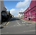
Dartmouth Street, Milford Haven
Ascending from Hamilton Terrace to Charles Street. The Haven Hotel http://www.geograph.org.uk/photo/5532868 is on the right.
Image: © Jaggery
Taken: 5 Sep 2017
0.06 miles
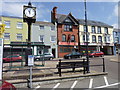
6
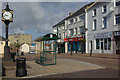
Charles Street, Milford Haven
The clock at the western end of Milford's main shopping street is showing the correct time.
Image: © Stephen McKay
Taken: 24 Aug 2010
0.06 miles
7
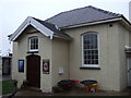
Friends' Meeting House
The date above the door is 1811. The Meeting House in Priory Road was established by the Quaker whalers from Nantucket who were persuaded to settle in the town at the end of the C18 with the aim of establishing a whaling industry here.
Image: © Natasha Ceridwen de Chroustchoff
Taken: 26 Oct 2007
0.07 miles
8
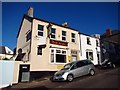
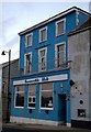
The Alma, Milford Haven
The Alma Public House,Priory Street,Milford Haven.
Image: © Arthur C Harris
Taken: 2 Oct 2014
0.07 miles
9
Conservative Club, Milford Haven
Conservative Club,Hamilton Terrace,Milford Haven.
Image: © Arthur C Harris
Taken: 30 Sep 2014
0.07 miles
10
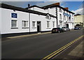
Grade II listed Lord Nelson Hotel, Hamilton Terrace, Milford Haven
Built 1795-1800 during the first phase of the construction of the new town of Milford Haven.
Originally named the New Inn, renamed for Lord Nelson's visit in August 1802. Grade II listed in 1993.
http://www.geograph.org.uk/photo/5532891 to the name sign on the right.
Image: © Jaggery
Taken: 5 Sep 2017
0.07 miles