IMAGES TAKEN NEAR TO
Hill Terrace, MILFORD HAVEN, SA73 1SN
Introduction
This page details the photographs taken nearby to Hill Terrace, SA73 1SN by members of the Geograph project.
The Geograph project started in 2005 with the aim of publishing, organising and preserving representative images for every square kilometre of Great Britain, Ireland and the Isle of Man.

There are currently over 7.5m images from over14,400 individuals and you can help contribute to the project by visiting https://www.geograph.org.uk
Image Map (Loading...)


Getting Data...Please wait
Leaflet Map data © OpenStreetMap
Images are licensed for reuse under creativecommons.org/licenses/by-sa/2.0
Notes
- Clicking on the map will re-center to the selected point.
- The higher the marker number, the further away the image location is from the centre of the postcode.
Image Listing (69 Images Found)
Images are licensed for reuse under creativecommons.org/licenses/by-sa/2.0
Image
Details
Distance
1
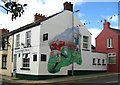
Gunning's Bar, St Clements Road, Neyland
Image: © Shaun Butler
Taken: 13 Aug 2008
0.05 miles
3
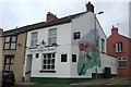
Gunning's Bar, Neyland
Gunning's Bar,St.Clements Road,Neyland
Image: © Arthur C Harris
Taken: 3 Oct 2014
0.05 miles
4
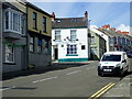
Gunning's Bar, Neyland
At the junction of the High Street and St Clement's Road
Image: © Eirian Evans
Taken: 31 Aug 2022
0.06 miles
5
Heading up Cambrian Road, Neyland
On the Coast Path, going towards the Cleddau Bridge
Image: © Eirian Evans
Taken: 31 Aug 2022
0.06 miles
6
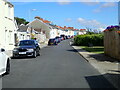
Ordnance Survey Cut Mark
This OS cut mark can be found on the wall west side of High Street. It marks a point 15.729m above mean sea level.
Image: © Adrian Dust
Taken: 18 Mar 2020
0.07 miles
7
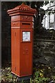
Neyland Victorian Postbox
*This letter box, perhaps the only one of its kind still in use in Wales, was originally sited on the railway station.It is hexagonal in shape and was made of cast iron between 1866 - 1879. The design, known as the Penfold Box, is believed to have originated with Anthony Trollope, the Victorian novelist.
* Info courtesy Tourist information panel.
Image: © Arthur C Harris
Taken: 7 Oct 2019
0.09 miles
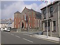
8
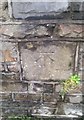
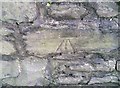
Ordnance Survey Cut Mark
This OS cut mark can be found on the wall of the Methodist Church, High Street. It marks a point 39.716m above mean sea level.
Image: © Adrian Dust
Taken: 18 Mar 2020
0.10 miles
10
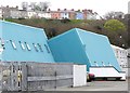
Futuristic Architecture in Neyland
Presume this is what is known as Avant-Garde Architecture?
Image: © Arthur C Harris
Taken: 21 Apr 2016
0.12 miles