IMAGES TAKEN NEAR TO
Kensington Road, MILFORD HAVEN, SA73 1RN
Introduction
This page details the photographs taken nearby to Kensington Road, SA73 1RN by members of the Geograph project.
The Geograph project started in 2005 with the aim of publishing, organising and preserving representative images for every square kilometre of Great Britain, Ireland and the Isle of Man.

There are currently over 7.5m images from over14,400 individuals and you can help contribute to the project by visiting https://www.geograph.org.uk
Image Map
Images are licensed for reuse under creativecommons.org/licenses/by-sa/2.0
Notes
- Clicking on the map will re-center to the selected point.
- The higher the marker number, the further away the image location is from the centre of the postcode.
Image Listing (13 Images Found)
Images are licensed for reuse under creativecommons.org/licenses/by-sa/2.0
Image
Details
Distance
2
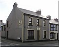
Pembrokeshire Pubs: The Forresters Arms, Neyland
Image: © Shaun Butler
Taken: 28 Sep 2008
0.11 miles
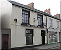
3
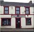
Pembrokeshire Pubs: Admiral Benbow, Neyland
Image: © Shaun Butler
Taken: 28 Sep 2008
0.11 miles
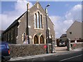
4
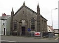
Presbyterian Church Neyland
Dated 1861
Image: © Arthur C Harris
Taken: 12 Oct 2017
0.12 miles
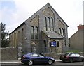
5
Bicentenial Memorial Chapel (converted)
Now 2 and 3 bedroomed apartments. (In my Mansion there are many rooms...)
Image: © Shaun Butler
Taken: 28 Sep 2008
0.15 miles
7
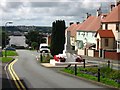
Neyland War Memorial
At the top of Riverside Avenue with Pembroke Dock in the distance.
Image: © Shaun Butler
Taken: 13 Aug 2008
0.17 miles
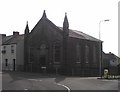
9
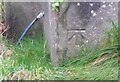
Ordnance Survey Cut Mark
This OS cut mark can be found on the south angle of the Baptist Chapel, High Street. It marks a point 49.117m above mean sea level.
Image: © Adrian Dust
Taken: 18 Mar 2020
0.19 miles
10
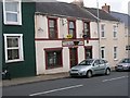
Pembrokeshire Pubs: The Coburg, Neyland
Image: © Shaun Butler
Taken: 28 Sep 2008
0.19 miles