IMAGES TAKEN NEAR TO
Water Street, MILFORD HAVEN, SA73 1RJ
Introduction
This page details the photographs taken nearby to Water Street, SA73 1RJ by members of the Geograph project.
The Geograph project started in 2005 with the aim of publishing, organising and preserving representative images for every square kilometre of Great Britain, Ireland and the Isle of Man.

There are currently over 7.5m images from over14,400 individuals and you can help contribute to the project by visiting https://www.geograph.org.uk
Image Map (Loading...)


Getting Data...Please wait
Leaflet Map data © OpenStreetMap
Images are licensed for reuse under creativecommons.org/licenses/by-sa/2.0
Notes
- Clicking on the map will re-center to the selected point.
- The higher the marker number, the further away the image location is from the centre of the postcode.
Image Listing (12 Images Found)
Images are licensed for reuse under creativecommons.org/licenses/by-sa/2.0
Image
Details
Distance
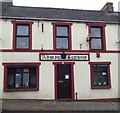
3
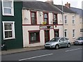
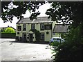
Pembrokeshire Pubs: Admiral Benbow, Neyland
Image: © Shaun Butler
Taken: 28 Sep 2008
0.08 miles
4
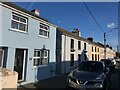
Terraced houses on Honeyborough Road, Neyland
Image: © Eirian Evans
Taken: 31 Aug 2022
0.16 miles
5
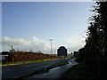
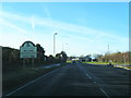
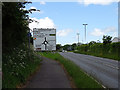
A477, east of the Honeyborough Roundabout
View of the A477 east of Honeyborough roundabout, heading for the Cleddau toll bridge.
Image: © Martyn Harries
Taken: 19 Nov 2010
0.19 miles
7
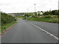
Approaching Honeyborough roundabout
On the A477 road.
Image: © John Lucas
Taken: 23 May 2016
0.22 miles
8
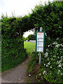
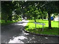
Bus stop beside the A477 road
Quite a frequent service between Pembroke Dock and Haverfordwest.
Image: © John Lucas
Taken: 23 May 2016
0.22 miles