IMAGES TAKEN NEAR TO
Ash Tree Close, MILFORD HAVEN, SA73 1LZ
Introduction
This page details the photographs taken nearby to Ash Tree Close, SA73 1LZ by members of the Geograph project.
The Geograph project started in 2005 with the aim of publishing, organising and preserving representative images for every square kilometre of Great Britain, Ireland and the Isle of Man.

There are currently over 7.5m images from over14,400 individuals and you can help contribute to the project by visiting https://www.geograph.org.uk
Image Map (Loading...)


Getting Data...Please wait
Leaflet Map data © OpenStreetMap
Images are licensed for reuse under creativecommons.org/licenses/by-sa/2.0
Notes
- Clicking on the map will re-center to the selected point.
- The higher the marker number, the further away the image location is from the centre of the postcode.
Image Listing (8 Images Found)
Images are licensed for reuse under creativecommons.org/licenses/by-sa/2.0
Image
Details
Distance
1
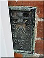
Ordnance Survey Flush Bracket (S0590)
This OS Flush Bracket can be found on the SW face of the chapel. It marks a point 75.190m above mean sea level.
Image: © Adrian Dust
Taken: 16 Apr 2017
0.03 miles
3
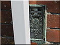
Ordnance Survey Flush Bracket S0590
This can be found on the wall of Sardis Chapel.
For more detail see : http://www.bench-marks.org.uk/bm20628
Image: © Peter Wood
Taken: 19 May 2013
0.03 miles
5

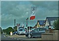
Convocation of the Traffic Cone and Allied Signs Union on Sardis Green
Image: © Colin Bell
Taken: 14 Jun 2008
0.04 miles
6
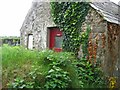
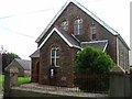
The 'Facilities' at Sardis Baptist church.
The sign says 'ladies' - no idea where the gents are...
Image: © Shaun Butler
Taken: 8 Aug 2008
0.05 miles
7
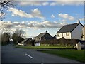
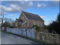
Housing at Sardis
On the road to Rosemarket.
Image: © Alan Hughes
Taken: 26 Feb 2024
0.06 miles
8
Seat Car Dealer At Sardis
On the Haverfordwest to Burton road
Image: © Deborah Tilley
Taken: 27 Jun 2015
0.19 miles