IMAGES TAKEN NEAR TO
Steynton, MILFORD HAVEN, SA73 1HA
Introduction
This page details the photographs taken nearby to SA73 1HA by members of the Geograph project.
The Geograph project started in 2005 with the aim of publishing, organising and preserving representative images for every square kilometre of Great Britain, Ireland and the Isle of Man.

There are currently over 7.5m images from over14,400 individuals and you can help contribute to the project by visiting https://www.geograph.org.uk
Image Map (Loading...)


Getting Data...Please wait
Leaflet Map data © OpenStreetMap
Images are licensed for reuse under creativecommons.org/licenses/by-sa/2.0
Notes
- Clicking on the map will re-center to the selected point.
- The higher the marker number, the further away the image location is from the centre of the postcode.
Image Listing (24 Images Found)
Images are licensed for reuse under creativecommons.org/licenses/by-sa/2.0
Image
Details
Distance
1
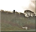
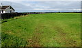
Fields Near Steynton
Just off the main Haverfordwest to Milford road.
Image: © Deborah Tilley
Taken: 22 Jan 2016
0.09 miles
2
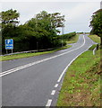
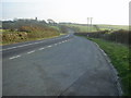
A4076 north of Steynton, Pembrokeshire
Double white lines in the middle of the road indicate no overtaking.
A parking area is 450 yards beyond the blue sign.
Image: © Jaggery
Taken: 5 Sep 2017
0.10 miles
3
"Ford" not a ford
The "Ford" on the map refers to the name of the building whose entrance is marked by the white boulders on the left, not a ford. It would be interesting to know how it got the name. (There is a dip in the road as it bridges a stream, not marked on the map, but not a sufficiently large one that one would expect there to have been a ford here in the past.)
Image: © Colin Bell
Taken: 14 Jun 2008
0.11 miles
4
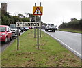
Warning sign - cattle at the northern edge of Milford Haven
Viewed across the A4076. The grey back of the Milford Haven boundary sign is behind the cattle warning sign.
Image: © Jaggery
Taken: 5 Sep 2017
0.12 miles
5
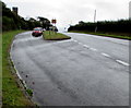
Lay-by on the A4076
Lay-by on the A4076 Haverfordwest to Milford Haven road with a view of Steynton in the distance.
Image: © Martyn Harries
Taken: 4 Mar 2011
0.17 miles
6
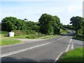
Northern approach to Steynton, Pembrokeshire
The A4076 is on the right. A side road is on the left. Formerly a separate village, Steynton has been absorbed by the northward expansion of Milford Haven. The tower of this church http://www.geograph.org.uk/photo/5527458 is in the background.
Image: © Jaggery
Taken: 5 Sep 2017
0.17 miles
7
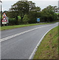
Northern boundary of Steynton, Pembrokeshire
Facing the A4076. Formerly a separate village, Steynton has been absorbed by the northward expansion of Milford Haven. The tower of this church http://www.geograph.org.uk/photo/5527458 is in the background.
Image: © Jaggery
Taken: 5 Sep 2017
0.17 miles
8
View north from Neyland Road field gates, Steynton, Milford Haven
From these gates. http://www.geograph.org.uk/photo/5532260
Image: © Jaggery
Taken: 5 Sep 2017
0.20 miles
9
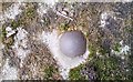
Ordnance Survey OSBM Bolt
This OSBM Bolt can be found on the north side of St Peter's Church. It marks a point 65.781m above mean sea level.
Image: © Adrian Dust
Taken: 16 Apr 2017
0.21 miles
10
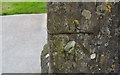
Ordnance Survey Cut Mark
This OS cut mark can be found on the west face of St Peter's Church. It marks a point 66.469m above mean sea level.
Image: © Adrian Dust
Taken: 16 Apr 2017
0.21 miles