IMAGES TAKEN NEAR TO
Steynton Road, MILFORD HAVEN, SA73 1AN
Introduction
This page details the photographs taken nearby to Steynton Road, SA73 1AN by members of the Geograph project.
The Geograph project started in 2005 with the aim of publishing, organising and preserving representative images for every square kilometre of Great Britain, Ireland and the Isle of Man.

There are currently over 7.5m images from over14,400 individuals and you can help contribute to the project by visiting https://www.geograph.org.uk
Image Map (Loading...)


Getting Data...Please wait
Leaflet Map data © OpenStreetMap
Images are licensed for reuse under creativecommons.org/licenses/by-sa/2.0
Notes
- Clicking on the map will re-center to the selected point.
- The higher the marker number, the further away the image location is from the centre of the postcode.
Image Listing (69 Images Found)
Images are licensed for reuse under creativecommons.org/licenses/by-sa/2.0
Image
Details
Distance
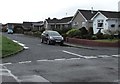
1
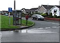
Phonebox and postbox on a Steynton corner
On the corner of Green Close and the A4076 Steynton Road.
Image: © Jaggery
Taken: 5 Sep 2017
0.03 miles
2
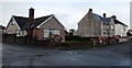
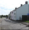
Houses on a Steynton corner
On the corner of Green Close (on the left) and Steynton Road.
Image: © Jaggery
Taken: 5 Sep 2017
0.04 miles
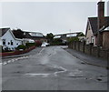
3
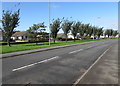
Tree-lined part of Steynton Road, Milford Haven
This part of the A4076 is in the north of Milford Haven, on the approach to Steynton.
Image: © Jaggery
Taken: 5 Sep 2017
0.04 miles
4
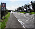
Warning sign - skid risk for 2 miles, Steynton Road, Milford Haven
The text is also in Welsh. Ahead along the A4076 towards the centre of Milford Haven.
Image: © Jaggery
Taken: 5 Sep 2017
0.05 miles
5
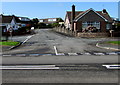
Junction of Green Close and Steynton Road, Milford Haven
Looking across the A4076 Steynton Road towards Green Close.
Image: © Jaggery
Taken: 5 Sep 2017
0.06 miles
6
Green Close, Steynton
Cul-de-sac on the northwest side of the A4076 Steynton Road.
Image: © Jaggery
Taken: 5 Sep 2017
0.06 miles
7
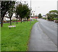
Southern boundary of Steynton, Pembrokeshire
Formerly a separate village, Steynton has been absorbed by the northward expansion of Milford Haven.
Image: © Jaggery
Taken: 5 Sep 2017
0.06 miles
8
Steynton bungalows, Milford Haven
Bungalows alongside a side road set back from the A4076 in Steynton in the north of Milford Haven.
Image: © Jaggery
Taken: 5 Sep 2017
0.07 miles
9
Castle Pill Road houses, Milford Haven
Near the northern end of Castle Pill Road, a dead end road
extending southwards for more than a kilometre to Castle Pill Farm.
Image: © Jaggery
Taken: 5 Sep 2017
0.07 miles
10
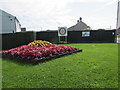
Rotary Club of Milford Haven garden in Steynton, Milford Haven
Located between Steynton Road and Castle Pill Road. A notice on the fence states that the Welsh Assembly Government has authorised the Rotary Club of Milford Haven to develop and maintain this garden to provide a pleasant approach to the town. Please do not diminish the effect by placing advertising material along the fence that Rotarians have painted to enhance the appearance.
The only item on the fence in early September 2017 is a Rotary Club notice showing Proud of Milford Haven.
A Rotary International sign is a metre or so in front of the fence.
Image: © Jaggery
Taken: 5 Sep 2017
0.08 miles