IMAGES TAKEN NEAR TO
Cutty Sark Drive, MILFORD HAVEN, SA73 1AF
Introduction
This page details the photographs taken nearby to Cutty Sark Drive, SA73 1AF by members of the Geograph project.
The Geograph project started in 2005 with the aim of publishing, organising and preserving representative images for every square kilometre of Great Britain, Ireland and the Isle of Man.

There are currently over 7.5m images from over14,400 individuals and you can help contribute to the project by visiting https://www.geograph.org.uk
Image Map (Loading...)


Getting Data...Please wait
Leaflet Map data © OpenStreetMap
Images are licensed for reuse under creativecommons.org/licenses/by-sa/2.0
Notes
- Clicking on the map will re-center to the selected point.
- The higher the marker number, the further away the image location is from the centre of the postcode.
Image Listing (12 Images Found)
Images are licensed for reuse under creativecommons.org/licenses/by-sa/2.0
Image
Details
Distance
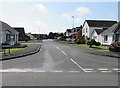
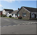
1
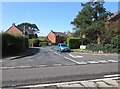
Cutty Sark Drive, Milford Haven
Cul-de-sac on the north side of the A4076 Steynton Road.
Image: © Jaggery
Taken: 5 Sep 2017
0.05 miles
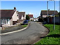
2
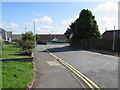
Towards Bunkers Hill, Milford Haven
Bunkers Hill is a roughly triangular area of houses accessed via this road from the A4076 Steynton Road.
Image: © Jaggery
Taken: 5 Sep 2017
0.10 miles
3
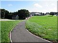
Path towards Mount Pleasant Way, Milford Haven
Set back from the east side of the A4076 Steynton Road.
Image: © Jaggery
Taken: 5 Sep 2017
0.13 miles
4
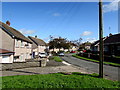
Mount Pleasant Way, Milford Haven
The north side of Mount Pleasant Way in an area of houses on the east side of the A4076 Steynton Road.
Image: © Jaggery
Taken: 5 Sep 2017
0.14 miles
5
Ardent Close, Steynton, Milford Haven
Cul-de-sac on the west side of Mariners Way.
Image: © Jaggery
Taken: 5 Sep 2017
0.20 miles
6
Mount Pleasant Way, Milford Haven
The central part of Mount Pleasant Way, an area of houses on the east side of the A4076 Steynton Road.
Image: © Jaggery
Taken: 5 Sep 2017
0.20 miles
7
Oberon Grove, Steynton, Milford Haven
Cul-de-sac on the southwest side of Mariners Way.
Image: © Jaggery
Taken: 5 Sep 2017
0.20 miles
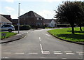
8
Corner of Mariners Way and Steynton Road, Milford Haven
The sign shows that Mariners Way on the left leads to Kensington Court.
Image: © Jaggery
Taken: 5 Sep 2017
0.23 miles
9
Ardent Close houses, Steynton, Milford Haven
Houses at the eastern end of Ardent Close viewed across Mariners Way.
Image: © Jaggery
Taken: 5 Sep 2017
0.24 miles
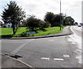
10
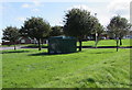
Grove Estate electricity substation, Steynton, Milford Haven
The dark green cabinet near the corner of Steynton Road and Mariners Way is a Western Power Distribution electricity substation, identifier GROVE ESTATE STEYNTON 60-3909.
Image: © Jaggery
Taken: 5 Sep 2017
0.24 miles