IMAGES TAKEN NEAR TO
Cumby Terrace, PEMBROKE DOCK, SA72 6YA
Introduction
This page details the photographs taken nearby to Cumby Terrace, SA72 6YA by members of the Geograph project.
The Geograph project started in 2005 with the aim of publishing, organising and preserving representative images for every square kilometre of Great Britain, Ireland and the Isle of Man.

There are currently over 7.5m images from over14,400 individuals and you can help contribute to the project by visiting https://www.geograph.org.uk
Image Map (Loading...)


Getting Data...Please wait
Leaflet Map data © OpenStreetMap
Images are licensed for reuse under creativecommons.org/licenses/by-sa/2.0
Notes
- Clicking on the map will re-center to the selected point.
- The higher the marker number, the further away the image location is from the centre of the postcode.
Image Listing (79 Images Found)
Images are licensed for reuse under creativecommons.org/licenses/by-sa/2.0
Image
Details
Distance
1
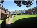
Green space between Melville Terrace and Cumby Terrace
Image: © Jonathan Thacker
Taken: 22 Jun 2018
0.01 miles
2
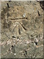
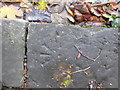
Ordnance Survey Cut Mark
This OS cut mark can be found on the south facing wall, Melville Street. It marks a point 15.091m above mean sea level.
Image: © Adrian Dust
Taken: 31 Oct 2015
0.05 miles
4
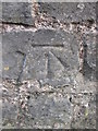
Ordnance Survey Cut Mark
This OS cut mark can be found on the south facing wall on Melville Street. It marks a point 16.827m above mean sea level.
Image: © Adrian Dust
Taken: 31 Oct 2015
0.06 miles
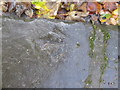
5
Ordnance Survey Pivot
This OS pivot can be found on a Kerb stone, west side of Melville Terrace. It marks a point 17.155m above mean sea level.
Image: © Adrian Dust
Taken: 31 Oct 2015
0.07 miles
6
Ordnance Survey Pivot
This OS pivot can be found on a Kerb stone at the junction of Melville Terrace & Victoria Road. It marks a point 25.121m above mean sea level.
Image: © Adrian Dust
Taken: 31 Oct 2015
0.08 miles
7
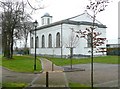
The Garrison Chapel, Pembroke Dock
See also Image
Image: © Humphrey Bolton
Taken: 31 Mar 2011
0.08 miles
8
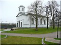
The Garrison Chapel, Pembroke Dock
This was built in 1830-1, but became disused and ruinous. It has been restored, and is owned by the County Council. There are plans to turn it into a heritage centre. It has been used for functions such as a 'Grand '1940s' Dance'.
Image: © Humphrey Bolton
Taken: 31 Mar 2011
0.08 miles
9
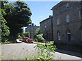
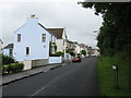
The Terrace, Pembroke Dock
Houses designed by E. Holl and built 1817-18. The farthest block is later and dates from 1877. They were the homes of senior dockyard officers.
Image: © Jonathan Thacker
Taken: 22 Jun 2018
0.08 miles
10
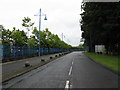
Meyrick Owen Way, Pembroke Dock
The end of the public road into Pembroke Dock's terminal. Next stop, Ireland.
Image: © Peter Whatley
Taken: 22 Jul 2009
0.10 miles