IMAGES TAKEN NEAR TO
Pembroke Street, PEMBROKE DOCK, SA72 6XH
Introduction
This page details the photographs taken nearby to Pembroke Street, SA72 6XH by members of the Geograph project.
The Geograph project started in 2005 with the aim of publishing, organising and preserving representative images for every square kilometre of Great Britain, Ireland and the Isle of Man.

There are currently over 7.5m images from over14,400 individuals and you can help contribute to the project by visiting https://www.geograph.org.uk
Image Map (Loading...)


Getting Data...Please wait
Leaflet Map data © OpenStreetMap
Images are licensed for reuse under creativecommons.org/licenses/by-sa/2.0
Notes
- Clicking on the map will re-center to the selected point.
- The higher the marker number, the further away the image location is from the centre of the postcode.
Image Listing (98 Images Found)
Images are licensed for reuse under creativecommons.org/licenses/by-sa/2.0
Image
Details
Distance
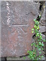
1
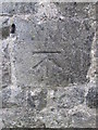
Ordnance Survey Cut Mark
This OS cut mark can be found on the SW wall junction, SE side of the road. It marks a point 23.235m above mean sea level.
Image: © Adrian Dust
Taken: 31 Oct 2015
0.03 miles
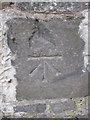
2
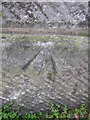
Ordnance Survey Pivot
This OS pivot can be found on the SE angle of the Market building. It marks a point 19.255m above mean sea level.
Image: © Adrian Dust
Taken: 31 Oct 2015
0.03 miles
3
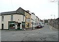
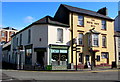
Pembroke Street, Pembroke Dock
The Maypole Dairy Co. Café is on the corner, and next to it the White Hart public house, dated 1820, which makes it one of the oldest buildings in the town.
Image: © Humphrey Bolton
Taken: 31 Mar 2011
0.05 miles
4
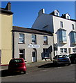
Inn Between guesthouse, Pembroke Dock
Bed & breakfast accommodation nestled in between two taller buildings in Pembroke Street.
Image: © Jaggery
Taken: 13 Mar 2015
0.05 miles
5
White Hart and Maypole Dairy Diner, Pembroke Dock
The White Hart inn at 3 Pembroke Street dates from 1820.
Maypole Dairy Diner is on the corner of Bush Street.
Image: © Jaggery
Taken: 13 Mar 2015
0.06 miles
6

The Masonic Hall, Bush Street, Pembroke Dock
Built in 1903-5.
Image: © Humphrey Bolton
Taken: 31 Mar 2011
0.06 miles
7
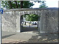
Gateway entrance to Pembroke Dock Heritage Museum
Image: © Eirian Evans
Taken: 31 Aug 2022
0.07 miles
8
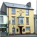
The White Hart, Pembroke Dock
The White Hart,Pembroke Street,Pembroke Dock.
Image: © Arthur C Harris
Taken: 1 Oct 2014
0.07 miles
9
Ordnance Survey Cut Mark
This OS cut mark can be found on the north facing school wall. It marks a point 19.065m above mean sea level.
Image: © Adrian Dust
Taken: 31 Oct 2015
0.08 miles
10
Ordnance Survey Cut Mark
This OS cut mark can be found on the east facing wall, Charlton Place. It marks a point 24.137m above mean sea level.
Image: © Adrian Dust
Taken: 31 Oct 2015
0.08 miles