IMAGES TAKEN NEAR TO
Meyrick Owen Way, PEMBROKE DOCK, SA72 6WS
Introduction
This page details the photographs taken nearby to Meyrick Owen Way, SA72 6WS by members of the Geograph project.
The Geograph project started in 2005 with the aim of publishing, organising and preserving representative images for every square kilometre of Great Britain, Ireland and the Isle of Man.

There are currently over 7.5m images from over14,400 individuals and you can help contribute to the project by visiting https://www.geograph.org.uk
Image Map
Images are licensed for reuse under creativecommons.org/licenses/by-sa/2.0
Notes
- Clicking on the map will re-center to the selected point.
- The higher the marker number, the further away the image location is from the centre of the postcode.
Image Listing (143 Images Found)
Images are licensed for reuse under creativecommons.org/licenses/by-sa/2.0
Image
Details
Distance
1

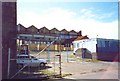
Pembroke Dock Heritage Centre
The Sunderland T9044 Flying Boat Centre + Maritime, Military and Memories at the Pembroke Dock Heritage Centre,opened by Her Majesty Queen Elizabeth II,accompanied by His Royal Highness the Duke of Edinburgh on Tuesday 29th April 2014.
Image: © Arthur C Harris
Taken: 1 Oct 2014
0.03 miles
2

The Flying Boat Centre, Pembroke Dock
The Sunderland T9044 Flying Boat Heritage Centre located in the Royal Dockyard Chapel, Meyrick Owen Way.
There was a Royal Air Force base in Pembroke Dock for nearly 30 years.
In 1943, when home to the Sunderland flying boats, it was the largest
operational base for flying boats in the world.
Image: © Jaggery
Taken: 13 Mar 2015
0.05 miles
3

The Avenue, Pembroke Dock
Looking towards the former Chapel.
Image: © Jonathan Thacker
Taken: 22 Jun 2018
0.05 miles
4

The Dockyard Chapel
Now the Pembroke Dock Heritage Centre.
Image: © Alan Hughes
Taken: 25 Feb 2024
0.05 miles
5
Through the gate Pembroke Dock
This is a view of an old seaplane hangar at Pembroke Dock used to house the Short Sunderland seaplane (nicknamed the flying Porcupine). This aircraft was a formidable adversary to the Axis powers. Please see
http://www.divetheworld.com/Diving/warbirds/SunderlandT9044/index.
Image: © Ant Basterfield
Taken: Unknown
0.05 miles
6

Eastern Sunderland Hangar, Pembroke Dock
Pembroke Dockyard building viewed from Commercial Row.
Image: © Jaggery
Taken: 13 Mar 2015
0.06 miles
7

Path by wall, Commercial Row
The path, carrying the Celtic Trail and Coast Path, runs alongside the wall, built in the early C19, enclosing the former Royal Dockyard.
Image: © M J Roscoe
Taken: 4 Jul 2023
0.06 miles
8

Ordnance Survey Pivot
This OS pivot can be found on the east facing wall, Commercial Row. It marks a point 13.950m above mean sea level.
Image: © Adrian Dust
Taken: 31 Oct 2015
0.07 miles
9
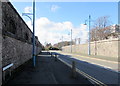
Meyrick Owen Way, Pembroke Dock
High walls on both sides of the road, viewed from the corner of Pembroke Street.
Image: © Jaggery
Taken: 13 Mar 2015
0.07 miles
10
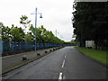
Meyrick Owen Way, Pembroke Dock
The end of the public road into Pembroke Dock's terminal. Next stop, Ireland.
Image: © Peter Whatley
Taken: 22 Jul 2009
0.07 miles