IMAGES TAKEN NEAR TO
Kings Gardens, PEMBROKE DOCK, SA72 6SR
Introduction
This page details the photographs taken nearby to Kings Gardens, SA72 6SR by members of the Geograph project.
The Geograph project started in 2005 with the aim of publishing, organising and preserving representative images for every square kilometre of Great Britain, Ireland and the Isle of Man.

There are currently over 7.5m images from over14,400 individuals and you can help contribute to the project by visiting https://www.geograph.org.uk
Image Map
Images are licensed for reuse under creativecommons.org/licenses/by-sa/2.0
Notes
- Clicking on the map will re-center to the selected point.
- The higher the marker number, the further away the image location is from the centre of the postcode.
Image Listing (18 Images Found)
Images are licensed for reuse under creativecommons.org/licenses/by-sa/2.0
Image
Details
Distance
1
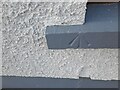
Ordnance Survey Pivot
This OS pivot can be found on the window sill of No14 Owen Street. It marks a point 48.698m above mean sea level.
Image: © Adrian Dust
Taken: 25 Mar 2022
0.08 miles
2
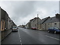
Military Road, Pembroke Dock
Uncannily reminiscent of main streets in Scottish townships.
Image: © Peter Whatley
Taken: 22 Jul 2009
0.13 miles
3
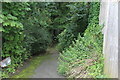
Footpath down from Sycamore Street, Pennar
The gate just visible in the centre leads to the left into the Sykemoor Woodland.
Image: © M J Roscoe
Taken: 1 Aug 2023
0.14 miles
4
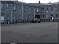
Southernmost corner of parade ground, Defensible Barracks
One corner of the square parade ground, this section was presumably living quarters. The square is enclosed above ground by the disused splendid two-storey stone building Image erected in the eighteen forties.
Image: © M J Roscoe
Taken: 17 Aug 2023
0.14 miles
5
Ordnance Survey Cut Mark
This OS cut mark can be found on the north face of St Patrick's Church. It marks a point 45.342m above mean sea level.
Image: © Adrian Dust
Taken: 25 Mar 2022
0.16 miles
6
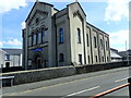
Pennar Community Church, Treowen Road
Formerly Bethany Baptist Chapel, built in 1818 and rebuilt in 1877
Image: © Eirian Evans
Taken: 31 Aug 2022
0.17 miles
7
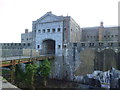
The Defensible Barracks
1841-6 defensible barracks, built to house officers and men of the Royal Marines, and, to a limited extent, to provide landward defence for the Royal Dockyard.
A Grade II Listed Building
Image: © Arthur C Harris
Taken: 12 Jul 2021
0.17 miles
8
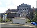
Defensible Barracks, Pembroke Dock
This impressive structure is located on Barrack Hill which overlooks the town and old naval dockyard area. It was constructed in the 1840's at a cost of £39,323.9s.9d [not sure what the 9d was spent on]. The site is surrounded by a deep dry moat and has diamond shaped stone and earth ramparts from which gunfire could be directed. Currently unused, but evidence of repair work ongoing.
Image: © Gordon Hatton
Taken: 22 Oct 2013
0.18 miles
9
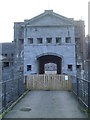
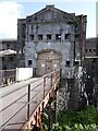
Main gate, Defensible Barracks
Originally reached by a drawbridge, the main gateway bears the inscription 'VR 1844'. The barracks were intended to be self supporting under siege conditions and has an 87000 gallon underground water tank supplied by rainwater. The barracks were originally manned by 9 officers, 7 NCOs and 240 other ranks. Original armament comprised sixteen 24 pounder cannons and over 600 muskets. The barracks were used by Royal Marines during both world wars, one of the men there being Arthur Lowe - Captain Mainwaring of 'Dad's Army'. Now grade 2 listed.
Image: © Gordon Hatton
Taken: 22 Oct 2013
0.18 miles
10
Old Defensible Barracks, northern gatehouse
Situated on the crest of Treowen or Barrack Hill, some 300m South of, and overlooking the Royal Dockyard. This sad looking building is Grade II* listed. It was completed in 1844 and was built to house the Royal Marines; in 1882 it become HQ of 9th Welsh Garrison Artillery Brigade.
Image: © Eirian Evans
Taken: 31 Aug 2022
0.18 miles