IMAGES TAKEN NEAR TO
Military Road, PEMBROKE DOCK, SA72 6SH
Introduction
This page details the photographs taken nearby to Military Road, SA72 6SH by members of the Geograph project.
The Geograph project started in 2005 with the aim of publishing, organising and preserving representative images for every square kilometre of Great Britain, Ireland and the Isle of Man.

There are currently over 7.5m images from over14,400 individuals and you can help contribute to the project by visiting https://www.geograph.org.uk
Image Map
Images are licensed for reuse under creativecommons.org/licenses/by-sa/2.0
Notes
- Clicking on the map will re-center to the selected point.
- The higher the marker number, the further away the image location is from the centre of the postcode.
Image Listing (10 Images Found)
Images are licensed for reuse under creativecommons.org/licenses/by-sa/2.0
Image
Details
Distance
1
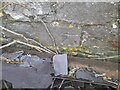
Ordnance Survey Cut Mark
This OS cut mark can be found on the north face of St Patrick's Church. It marks a point 45.342m above mean sea level.
Image: © Adrian Dust
Taken: 25 Mar 2022
0.05 miles
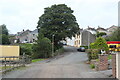
2
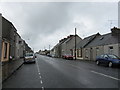
Military Road, Pembroke Dock
Uncannily reminiscent of main streets in Scottish townships.
Image: © Peter Whatley
Taken: 22 Jul 2009
0.08 miles
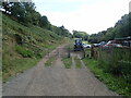
3
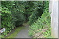
Footpath down from Sycamore Street, Pennar
The gate just visible in the centre leads to the left into the Sykemoor Woodland.
Image: © M J Roscoe
Taken: 1 Aug 2023
0.11 miles
4

Ordnance Survey Pivot
This OS pivot can be found on the window sill of No14 Owen Street. It marks a point 48.698m above mean sea level.
Image: © Adrian Dust
Taken: 25 Mar 2022
0.15 miles
6
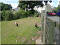
Lower end of Sycamore Street, Pennar
The Coast Path comes down the street on to a track and into farmland behind the camera.
Image: © M J Roscoe
Taken: 1 Aug 2023
0.20 miles
7
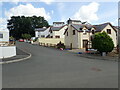
Sycamore Woods
Street on a housing estate in Pennar
Image: © Eirian Evans
Taken: 31 Aug 2022
0.21 miles
8
Pembrokeshire Coast Path
Leaving the outskirts of Pembroke Dock, the path now passes along a stretch of countryside. It follows a tributary of the River Pembroke, then the river itself to head for Pembroke.
Image: © Eirian Evans
Taken: 31 Aug 2022
0.22 miles
9
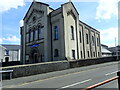
Pennar Community Church, Treowen Road
Formerly Bethany Baptist Chapel, built in 1818 and rebuilt in 1877
Image: © Eirian Evans
Taken: 31 Aug 2022
0.23 miles
10
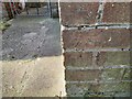
Ordnance Survey Cut Mark
This OS cut mark can be found on No95 Military Road. It marks a point 56.494m above mean sea level.
Image: © Adrian Dust
Taken: 25 Mar 2022
0.23 miles