IMAGES TAKEN NEAR TO
Lavinia Drive, PEMBROKE DOCK, SA72 6QY
Introduction
This page details the photographs taken nearby to Lavinia Drive, SA72 6QY by members of the Geograph project.
The Geograph project started in 2005 with the aim of publishing, organising and preserving representative images for every square kilometre of Great Britain, Ireland and the Isle of Man.

There are currently over 7.5m images from over14,400 individuals and you can help contribute to the project by visiting https://www.geograph.org.uk
Image Map (Loading...)


Getting Data...Please wait
Leaflet Map data © OpenStreetMap
Images are licensed for reuse under creativecommons.org/licenses/by-sa/2.0
Notes
- Clicking on the map will re-center to the selected point.
- The higher the marker number, the further away the image location is from the centre of the postcode.
Image Listing (19 Images Found)
Images are licensed for reuse under creativecommons.org/licenses/by-sa/2.0
Image
Details
Distance
1
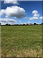
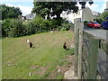
Suburbs of Pembroke Dock
Looking back over farmland towards houses at Pennar. From the Coast Path
Image: © Eirian Evans
Taken: 31 Aug 2022
0.08 miles
2
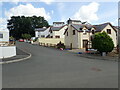
Sycamore Woods
Street on a housing estate in Pennar
Image: © Eirian Evans
Taken: 31 Aug 2022
0.08 miles
3
Pembrokeshire Coast Path
Leaving the outskirts of Pembroke Dock, the path now passes along a stretch of countryside. It follows a tributary of the River Pembroke, then the river itself to head for Pembroke.
Image: © Eirian Evans
Taken: 31 Aug 2022
0.09 miles
4
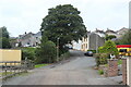
Lower end of Sycamore Street, Pennar
The Coast Path comes down the street on to a track and into farmland behind the camera.
Image: © M J Roscoe
Taken: 1 Aug 2023
0.10 miles
6
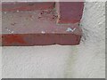
Ordnance Survey Pivot
This much painted over OS pivot can be found on the window sill of No42 North Street. It marks a point 53.079m above mean sea level.
Image: © Adrian Dust
Taken: 25 Mar 2022
0.11 miles
7
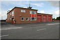
Pembroke Dock Fire Station
Very important station bearing in mind our new LNG plant (which will supply everyone with a large proportion of their natural gas) and our two oil refineries.
Image: © John Horne
Taken: 28 Jun 2007
0.18 miles
8
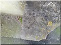
Ordnance Survey Rivet
This OS rivet can be found on the stone next to No82 High Street. It marks a point 60.112m above mean sea level.
Image: © Adrian Dust
Taken: 25 Mar 2022
0.19 miles
9
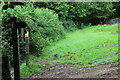
Hedgerow by public footpath
The path comes down hill from the camera crosses a track and goes to the kissing gate Image at footbridge over Jacob's Pill, but the path appears little used. The arms on the signpost indicate the route of the Pembrokeshire Coast Path.
Image: © M J Roscoe
Taken: 1 Aug 2023
0.19 miles
10
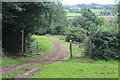
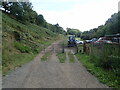
Footpath crossroads, Sykemoor, Pennar
One path continues along the track through the gate; the other path comes down hill by the signpost and continues to the right alongside the hedge Image The Coast Path comes down the track and turns to the left by the signpost.
Image: © M J Roscoe
Taken: 1 Aug 2023
0.20 miles