IMAGES TAKEN NEAR TO
Imble Lane, PEMBROKE DOCK, SA72 6PN
Introduction
This page details the photographs taken nearby to Imble Lane, SA72 6PN by members of the Geograph project.
The Geograph project started in 2005 with the aim of publishing, organising and preserving representative images for every square kilometre of Great Britain, Ireland and the Isle of Man.

There are currently over 7.5m images from over14,400 individuals and you can help contribute to the project by visiting https://www.geograph.org.uk
Image Map
Images are licensed for reuse under creativecommons.org/licenses/by-sa/2.0
Notes
- Clicking on the map will re-center to the selected point.
- The higher the marker number, the further away the image location is from the centre of the postcode.
Image Listing (10 Images Found)
Images are licensed for reuse under creativecommons.org/licenses/by-sa/2.0
Image
Details
Distance
1

Imble Farm, Imble Lane, Pembroke Dock
An enjoyable walk down to the Pembrokeshire Coast Path and the water. Gives views of Pembroke Castle.
Image: © John Horne
Taken: 27 Jun 2007
0.04 miles
2

Imble Lane, Pembroke Dock
Lane further from the farm. Go through gate to get to the river and coast path.
Image: © John Horne
Taken: 27 Jun 2007
0.12 miles
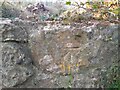
3

Ordnance Survey Cut Mark
This OS cut mark can be found on the gatepost west side of the Imble Lane. It marks a point 49.535m above mean sea level.
Image: © Adrian Dust
Taken: 25 Mar 2022
0.17 miles
4
Ordnance Survey Cut Mark
This OS cut mark can be found on the wall south side of the track. It marks a point 10.193m above mean sea level.
Image: © Adrian Dust
Taken: 25 Mar 2022
0.19 miles
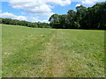
5

Kissing gate near End of Imble Lane
The path fom the gate descends to stepping stones in a stream.
Image: © M J Roscoe
Taken: 1 Aug 2023
0.19 miles

8

View from Pembroke Road
Looking west from the ridge above Pembroke Dock. The LNG facility at Waterston on the far side of the Cleddau estuary can be seen in the background.
Image: © Simon Mortimer
Taken: 11 Aug 2012
0.22 miles
9
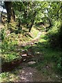
Pembrokeshire Coast Path
Having squeezes through the stile Image] the path now fords a small stream
Image: © Eirian Evans
Taken: 31 Aug 2022
0.24 miles
10
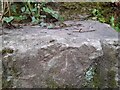
Ordnance Survey Pivot
This OS pivot can be found on the top step of the stile. It marks a point 18.639m above mean sea level.
Image: © Adrian Dust
Taken: 25 Mar 2022
0.24 miles