IMAGES TAKEN NEAR TO
Imble Close, PEMBROKE DOCK, SA72 6PJ
Introduction
This page details the photographs taken nearby to Imble Close, SA72 6PJ by members of the Geograph project.
The Geograph project started in 2005 with the aim of publishing, organising and preserving representative images for every square kilometre of Great Britain, Ireland and the Isle of Man.

There are currently over 7.5m images from over14,400 individuals and you can help contribute to the project by visiting https://www.geograph.org.uk
Image Map
Images are licensed for reuse under creativecommons.org/licenses/by-sa/2.0
Notes
- Clicking on the map will re-center to the selected point.
- The higher the marker number, the further away the image location is from the centre of the postcode.
Image Listing (18 Images Found)
Images are licensed for reuse under creativecommons.org/licenses/by-sa/2.0
Image
Details
Distance

2

View from Pembroke Road
Looking west from the ridge above Pembroke Dock. The LNG facility at Waterston on the far side of the Cleddau estuary can be seen in the background.
Image: © Simon Mortimer
Taken: 11 Aug 2012
0.10 miles
3
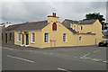
Red Rose Inn
Good food. Located at the end of the High Street in Pembroke Dock - nearly opposite the Fire Station.
Image: © John Horne
Taken: 28 Jun 2007
0.11 miles
4
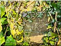
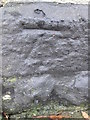
Ordnance Survey Cut Mark
This OS cut mark can be found on the gatepost west side of the Imble Lane. It marks a point 49.535m above mean sea level.
Image: © Adrian Dust
Taken: 25 Mar 2022
0.12 miles
5
Ordnance Survey Cut Mark
This OS cut mark can be found on the wall of No1 Park View Crescent on Picton Place. It marks a point 58.235m above mean sea level.
Image: © Adrian Dust
Taken: 25 Mar 2022
0.13 miles
6
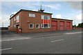
Pembroke Dock Fire Station
Very important station bearing in mind our new LNG plant (which will supply everyone with a large proportion of their natural gas) and our two oil refineries.
Image: © John Horne
Taken: 28 Jun 2007
0.16 miles
7
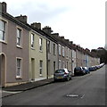
Houses on the east side of Gwyther Street, Pembroke Dock
Looking south from near the corner of Bush Street.
Image: © Jaggery
Taken: 13 Mar 2015
0.17 miles
8
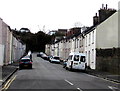
South along Gwyther Street, Pembroke Dock
From the Bush Street end.
Image: © Jaggery
Taken: 13 Mar 2015
0.17 miles
9
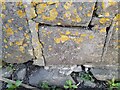
Ordnance Survey Cut Mark
This OS cut mark can be found on No54 Prospect Place. It marks a point 49.761m above mean sea level.
Image: © Adrian Dust
Taken: 31 Oct 2015
0.17 miles
10

Ordnance Survey Rivet
This OS rivet can be found on the stone next to No82 High Street. It marks a point 60.112m above mean sea level.
Image: © Adrian Dust
Taken: 25 Mar 2022
0.21 miles