IMAGES TAKEN NEAR TO
St. Teilos Road, PEMBROKE DOCK, SA72 6LJ
Introduction
This page details the photographs taken nearby to St. Teilos Road, SA72 6LJ by members of the Geograph project.
The Geograph project started in 2005 with the aim of publishing, organising and preserving representative images for every square kilometre of Great Britain, Ireland and the Isle of Man.

There are currently over 7.5m images from over14,400 individuals and you can help contribute to the project by visiting https://www.geograph.org.uk
Image Map
Images are licensed for reuse under creativecommons.org/licenses/by-sa/2.0
Notes
- Clicking on the map will re-center to the selected point.
- The higher the marker number, the further away the image location is from the centre of the postcode.
Image Listing (17 Images Found)
Images are licensed for reuse under creativecommons.org/licenses/by-sa/2.0
Image
Details
Distance
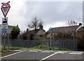
1
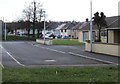
Towards St John's Road, Pembroke Dock
From Hawkstone Road.
Image: © Jaggery
Taken: 13 Mar 2015
0.19 miles
2

View from Pembroke Road
Looking west from the ridge above Pembroke Dock. The LNG facility at Waterston on the far side of the Cleddau estuary can be seen in the background.
Image: © Simon Mortimer
Taken: 11 Aug 2012
0.19 miles
3
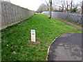
No Dig Zone marker, Pembroke Dock
Near a railway perimeter fence, the marker shows the name Valero,
owners of the Pembroke Oil Refinery. The pipe diameter shown is 16 inches.
Image: © Jaggery
Taken: 13 Mar 2015
0.21 miles
4
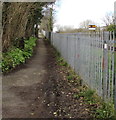
Path alongside a railway perimeter fence, Pembroke Dock
Looking towards the centre of Pembroke Dock at the edge of the Pembroke Dock branch of the West Wales line.
If the yellow signal doesn't look real, that's because it's only a depiction. http://www.geograph.org.uk/photo/4395004
Image: © Jaggery
Taken: 13 Mar 2015
0.22 miles
5
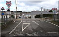
South side of Llanion Crossing, Pembroke Dock
A single track railway crosses the road named Llanion Cottages. There is an unusual arrangement at this ungated level crossing. A train approaching the crossing stops at a trackside Stop sign, http://www.geograph.org.uk/photo/4394929 sounds its horn, then proceeds slowly over the crossing. This location is less than 600 metres from the end of the line at Pembroke Dock, so stopping here is only a minor inconvenience for a train travelling in either direction. Most of the time, there is no vehicle on, or about to use, the crossing. Almost all the houses hereabouts are north of the crossing (ahead).
Image: © Jaggery
Taken: 13 Mar 2015
0.22 miles
6
Keep Llanion Crossing Clear, Pembroke Dock
On the approach to this http://www.geograph.org.uk/photo/4394917 level crossing. The depiction of a stylised steam locomotive is from another era. Trains on this line have been diesel hauled for about 50 years.
Image: © Jaggery
Taken: 13 Mar 2015
0.22 miles
7

Llanion Halt railway station (site), Pembrokeshire
Opened in 1905 by the Great Western Railway on the line from Pembroke to Pembroke Dock, this short-lived Halt closed in 1908.
View west towards Pembroke Dock. The single platform was to the left of the track.
Image: © Nigel Thompson
Taken: 2 Sep 2022
0.22 miles
8

Stop - whistle before proceeding sign, Pembroke Dock
Viewed from a path at the perimeter of the railway on the approach to a level crossing. This http://www.geograph.org.uk/photo/4394917 gives details.
Image: © Jaggery
Taken: 13 Mar 2015
0.22 miles
9
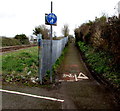
Footpath and cycleway east of Llanion Crossing, Pembroke Dock
From this http://www.geograph.org.uk/photo/4394917 level crossing.
Image: © Jaggery
Taken: 13 Mar 2015
0.22 miles
10

Hawkstone Road houses, Pembroke Dock
Viewed from the corner of Trinity Road.
Image: © Jaggery
Taken: 13 Mar 2015
0.23 miles