IMAGES TAKEN NEAR TO
Connaught Place, PEMBROKE DOCK, SA72 6EZ
Introduction
This page details the photographs taken nearby to Connaught Place, SA72 6EZ by members of the Geograph project.
The Geograph project started in 2005 with the aim of publishing, organising and preserving representative images for every square kilometre of Great Britain, Ireland and the Isle of Man.

There are currently over 7.5m images from over14,400 individuals and you can help contribute to the project by visiting https://www.geograph.org.uk
Image Map (Loading...)


Getting Data...Please wait
Leaflet Map data © OpenStreetMap
Images are licensed for reuse under creativecommons.org/licenses/by-sa/2.0
Notes
- Clicking on the map will re-center to the selected point.
- The higher the marker number, the further away the image location is from the centre of the postcode.
Image Listing (50 Images Found)
Images are licensed for reuse under creativecommons.org/licenses/by-sa/2.0
Image
Details
Distance
1
The Guard Room - at the junction of Essex Road and Devonshire Road
This former Army building has now been converted into dwellings.
Image: © Ruth Sharville
Taken: 11 Feb 2009
0.01 miles
2
Junction of Connaught Place with Essex Road
Image: © Ruth Sharville
Taken: 11 Feb 2009
0.06 miles
3
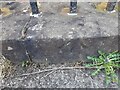
Ordnance Survey Pivot
This OS pivot can be found on the wall on the NW face of the old Government Offices building on Essex Road. It marks a point 39.285m above mean sea level.
Image: © Adrian Dust
Taken: 25 Mar 2022
0.06 miles
4
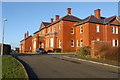
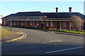
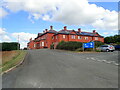
Pembrokeshire Coast National Park Headquarters
Image: © Ruth Sharville
Taken: 11 Feb 2009
0.06 miles
6
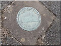
Pavement plaque, Pembroke Dock
A cast bronze plaque marking the Hut Camp, stop no.5 on the town Heritage Trail - "This was once the home to Hut Camp, later known as Llanion Barracks. Originally these barracks, which could house anything up to 1000 men, were built in only six weeks! Infantry regiments from all over the country have occupied these barracks. The red-bricked barracks we see standing today were built later in 1906. During the Second World War, American GIs of the 110th US Infantry Regiment were based here and this led to a visit from the Supreme Allied Commander, General Dwight D. Eisenhower who arrived here in at Llanion in 1944."
(https://www.robertjakes.co.uk/enl_RP_PD_trail.htm)
There are 39 plaques in all on the trail.
Image: © Eirian Evans
Taken: 31 Aug 2022
0.08 miles
7
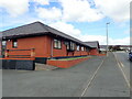
Offices of the Pembrokeshire Coast National Park Authority
Image: © Eirian Evans
Taken: 31 Aug 2022
0.08 miles
8
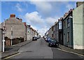
Arthur Street, Pembroke Dock
Viewed from the A4139 London Road end looking up towards Canterbury Road.
Image: © Jaggery
Taken: 13 Mar 2015
0.09 miles