IMAGES TAKEN NEAR TO
Bush Street, PEMBROKE DOCK, SA72 6AN
Introduction
This page details the photographs taken nearby to Bush Street, SA72 6AN by members of the Geograph project.
The Geograph project started in 2005 with the aim of publishing, organising and preserving representative images for every square kilometre of Great Britain, Ireland and the Isle of Man.

There are currently over 7.5m images from over14,400 individuals and you can help contribute to the project by visiting https://www.geograph.org.uk
Image Map (Loading...)


Getting Data...Please wait
Leaflet Map data © OpenStreetMap
Images are licensed for reuse under creativecommons.org/licenses/by-sa/2.0
Notes
- Clicking on the map will re-center to the selected point.
- The higher the marker number, the further away the image location is from the centre of the postcode.
Image Listing (172 Images Found)
Images are licensed for reuse under creativecommons.org/licenses/by-sa/2.0
Image
Details
Distance
1
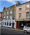
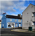
Club Martello, Pembroke Dock
The club at 55 Bush Street was founded as a Conservative Club in 1886.
It was named Club Martello on changing to a private social club in 2008.
New members are welcome.
Image: © Jaggery
Taken: 13 Mar 2015
0.01 miles
2
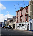
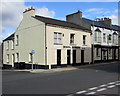
Donovan's, Pembroke Dock
Donovan's bar & grill in Bush Street is home of Pembroke Borough Football Club (the Magpies).
Image: © Jaggery
Taken: 13 Mar 2015
0.01 miles
3
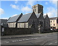
East side of the Parish Church of St John the Evangelist, Pembroke Dock
Viewed across Church Street. The Victorian church is in the Church in Wales Diocese of St Davids.
Image: © Jaggery
Taken: 13 Mar 2015
0.02 miles
4
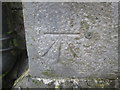
Ordnance Survey 1GL Bolt
This OS Bolt can be found on the north face of St John's Church. It marks a point 18.963m above mean sea level.
Image: © Adrian Dust
Taken: 31 Oct 2015
0.02 miles
5
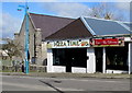
Pizza Time and Taste of Thai, Pembroke Dock
Two takeaways in Meyrick Street. St Mary's RC church http://www.geograph.org.uk/photo/4397984 is on the left.
Image: © Jaggery
Taken: 13 Mar 2015
0.03 miles
6
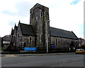
Parish Church of St John the Evangelist, Pembroke Dock
On the corner of Church Street and Bush Street, the Victorian church is in the Church in Wales Diocese of St Davids. Pembroke Dock War Memorial http://www.geograph.org.uk/photo/4397627 is on the left.
Image: © Jaggery
Taken: 13 Mar 2015
0.03 miles
7
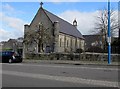
St Mary's Church, Meyrick Street, Pembroke Dock
Roman Catholic church in the Diocese of Menevia.
Image: © Jaggery
Taken: 13 Mar 2015
0.03 miles
8
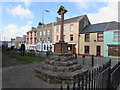
Pembroke Dock War Memorial
Erected in 1921 in the NE corner of the churchyard of St John the Evangelist, http://www.geograph.org.uk/photo/4383915
on the corner of Church Street and Bush Street.
Image: © Jaggery
Taken: 13 Mar 2015
0.03 miles
9
Upper Meyrick Street feeder pillar, Pembroke Dock
The feeder pillar is the low voltage dark green Western Power Distribution metal box on the right.
Image: © Jaggery
Taken: 13 Mar 2015
0.03 miles
10
Dental Surgery, Pembroke Dock
On the corner of Bush Street and Lewis Street. Bush Tavern http://www.geograph.org.uk/photo/4397513 is on the right.
Image: © Jaggery
Taken: 13 Mar 2015
0.03 miles