IMAGES TAKEN NEAR TO
Cosheston, PEMBROKE DOCK, SA72 4UN
Introduction
This page details the photographs taken nearby to SA72 4UN by members of the Geograph project.
The Geograph project started in 2005 with the aim of publishing, organising and preserving representative images for every square kilometre of Great Britain, Ireland and the Isle of Man.

There are currently over 7.5m images from over14,400 individuals and you can help contribute to the project by visiting https://www.geograph.org.uk
Image Map
Images are licensed for reuse under creativecommons.org/licenses/by-sa/2.0
Notes
- Clicking on the map will re-center to the selected point.
- The higher the marker number, the further away the image location is from the centre of the postcode.
Image Listing (17 Images Found)
Images are licensed for reuse under creativecommons.org/licenses/by-sa/2.0
Image
Details
Distance
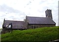
2
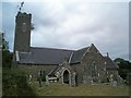
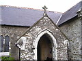
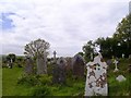
Cosheston Church
Dedicated to St Michael and All Angels, hence the striking weather vane.
Image: © Jennifer Luther Thomas
Taken: 10 Aug 2006
0.11 miles
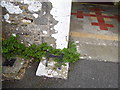
10
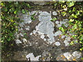
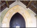
Ordnance Survey Cut Mark
This OS cut mark can be found on the east face of St Michael's Church. It marks a point 36.106m above mean sea level.
Image: © Adrian Dust
Taken: 31 Oct 2015
0.13 miles