IMAGES TAKEN NEAR TO
Cosheston, PEMBROKE DOCK, SA72 4TU
Introduction
This page details the photographs taken nearby to SA72 4TU by members of the Geograph project.
The Geograph project started in 2005 with the aim of publishing, organising and preserving representative images for every square kilometre of Great Britain, Ireland and the Isle of Man.

There are currently over 7.5m images from over14,400 individuals and you can help contribute to the project by visiting https://www.geograph.org.uk
Image Map (Loading...)


Getting Data...Please wait
Leaflet Map data © OpenStreetMap
Images are licensed for reuse under creativecommons.org/licenses/by-sa/2.0
Notes
- Clicking on the map will re-center to the selected point.
- The higher the marker number, the further away the image location is from the centre of the postcode.
Image Listing (8 Images Found)
Images are licensed for reuse under creativecommons.org/licenses/by-sa/2.0
Image
Details
Distance
7
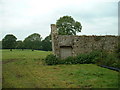
Derelict barn in Cosheston Hall park
Somebody has taken the trouble to brick up the doorway - pity about the roof.
Image: © David Medcalf
Taken: 1 Oct 2007
0.21 miles
8
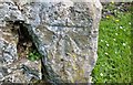
Ordnance Survey Cut Mark
This OS cut mark can be found on the barn at Mountain Gate. It marks a point 54.004m above mean sea level.
Image: © Adrian Dust
Taken: 6 Apr 2017
0.23 miles