IMAGES TAKEN NEAR TO
PEMBROKE DOCK, SA72 4SL
Introduction
This page details the photographs taken nearby to SA72 4SL by members of the Geograph project.
The Geograph project started in 2005 with the aim of publishing, organising and preserving representative images for every square kilometre of Great Britain, Ireland and the Isle of Man.

There are currently over 7.5m images from over14,400 individuals and you can help contribute to the project by visiting https://www.geograph.org.uk
Image Map
Images are licensed for reuse under creativecommons.org/licenses/by-sa/2.0
Notes
- Clicking on the map will re-center to the selected point.
- The higher the marker number, the further away the image location is from the centre of the postcode.
Image Listing (15 Images Found)
Images are licensed for reuse under creativecommons.org/licenses/by-sa/2.0
Image
Details
Distance
3
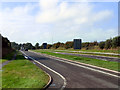
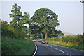
A477
Looking west, along the A477, from the junction with the A4075
Image: © David Dixon
Taken: 10 Sep 2011
0.05 miles
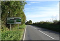
4
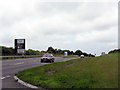
New road junction
Where the A4075 (on the right) meets the A477(T). (Re-sited?) milepost states 31m to Carmarthen. The turning for Cosheston is beyond, on the left.
Image: © Jennifer Luther Thomas
Taken: 11 Aug 2006
0.07 miles
5
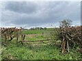
Footpath between trunk roads
From A4075 to A477.
Image: © Alan Hughes
Taken: 23 Apr 2023
0.07 miles

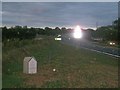
8
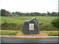
Farmland and monument near Upper Nash
The plaque commemorates the opening of the new road layout and junction between the A477 and the A4075 with the financial help of the European Commission.
Image: © David Medcalf
Taken: 1 Oct 2007
0.14 miles
10
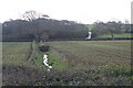
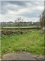
View across field to hillside lane
The lane, a private road leads up from the A4075 (roadside hedge horizontal centre) towards Strawberry Hill Farm.
Image: © M J Roscoe
Taken: 3 Nov 2023
0.17 miles