IMAGES TAKEN NEAR TO
Cosheston, PEMBROKE DOCK, SA72 4SE
Introduction
This page details the photographs taken nearby to SA72 4SE by members of the Geograph project.
The Geograph project started in 2005 with the aim of publishing, organising and preserving representative images for every square kilometre of Great Britain, Ireland and the Isle of Man.

There are currently over 7.5m images from over14,400 individuals and you can help contribute to the project by visiting https://www.geograph.org.uk
Image Map (Loading...)


Getting Data...Please wait
Leaflet Map data © OpenStreetMap
Images are licensed for reuse under creativecommons.org/licenses/by-sa/2.0
Notes
- Clicking on the map will re-center to the selected point.
- The higher the marker number, the further away the image location is from the centre of the postcode.
Image Listing (5 Images Found)
Images are licensed for reuse under creativecommons.org/licenses/by-sa/2.0
Image
Details
Distance
1
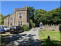
Upton Lodge
At the entrance to Upton Castle.
Image: © David Medcalf
Taken: 8 Aug 2022
0.00 miles
2
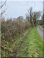
Roadside ditch
Leading to Upton Castle.
Image: © Alan Hughes
Taken: 27 Feb 2024
0.07 miles
4
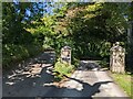
Farm to the left, Castle to the right (strictly private)
Upton Farm is adjacent to the Castle, but has a separate access road to maintain the privacy of the Castle.
Image: © David Medcalf
Taken: 8 Aug 2022
0.23 miles
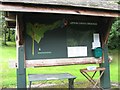
5
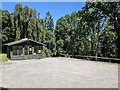
The car park for the Gardens
The gardens are closed, so no parking is required.
Image: © David Medcalf
Taken: 8 Aug 2022
0.24 miles