IMAGES TAKEN NEAR TO
Waterloo Industrial Estate, Eastern Avenue, PEMBROKE DOCK, SA72 4RT
Introduction
This page details the photographs taken nearby to Waterloo Industrial Estate, Eastern Avenue, SA72 4RT by members of the Geograph project.
The Geograph project started in 2005 with the aim of publishing, organising and preserving representative images for every square kilometre of Great Britain, Ireland and the Isle of Man.

There are currently over 7.5m images from over14,400 individuals and you can help contribute to the project by visiting https://www.geograph.org.uk
Image Map (Loading...)


Getting Data...Please wait
Leaflet Map data © OpenStreetMap
Images are licensed for reuse under creativecommons.org/licenses/by-sa/2.0
Notes
- Clicking on the map will re-center to the selected point.
- The higher the marker number, the further away the image location is from the centre of the postcode.
Image Listing (9 Images Found)
Images are licensed for reuse under creativecommons.org/licenses/by-sa/2.0
Image
Details
Distance
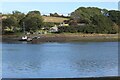
1
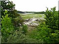
Cosheston Pill
Cosheston Pill, with Burton visible on the opposite bank of the Cleddau - strictly speaking it's the Daucleddau at this point, as the East and West rivers have joined just up-river to the right.
Image: © Shaun Butler
Taken: 17 Jun 2008
0.17 miles
2
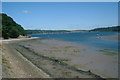
Looking towards the River Cleddau from the Water Sports centre
Image: © Angela Jones
Taken: 7 Aug 2006
0.17 miles
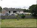
3
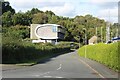
bombora offices
The sign outside the building says, 'wave power' and this reflected in the shape of the building. Ferry Wood is in the background.
Image: © M J Roscoe
Taken: 13 Sep 2023
0.19 miles
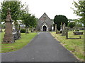
5
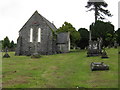
Another Chapel, Pembroke Dock Cemetery
Image: © Peter Whatley
Taken: 22 Jul 2009
0.22 miles

7
Point House, Cosheston Point
Riverside house near the mouth of Cosheston Pill.
Image: © M J Roscoe
Taken: 13 Sep 2023
0.24 miles
9
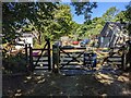
Entry to Point Farm is discouraged
A collection of 'borrowed ' signs deter visitors - one on the shed on the right declares that "Live Firing is in Progress". But a bridleway passes through the yard, down to the shoreline. I guess it is not much used! Point Farm (on the sign on the gate) is Point House on the OS map.
Image: © David Medcalf
Taken: 8 Aug 2022
0.25 miles