IMAGES TAKEN NEAR TO
Waterloo, PEMBROKE DOCK, SA72 4RR
Introduction
This page details the photographs taken nearby to SA72 4RR by members of the Geograph project.
The Geograph project started in 2005 with the aim of publishing, organising and preserving representative images for every square kilometre of Great Britain, Ireland and the Isle of Man.

There are currently over 7.5m images from over14,400 individuals and you can help contribute to the project by visiting https://www.geograph.org.uk
Image Map (Loading...)


Getting Data...Please wait
Leaflet Map data © OpenStreetMap
Images are licensed for reuse under creativecommons.org/licenses/by-sa/2.0
Notes
- Clicking on the map will re-center to the selected point.
- The higher the marker number, the further away the image location is from the centre of the postcode.
Image Listing (25 Images Found)
Images are licensed for reuse under creativecommons.org/licenses/by-sa/2.0
Image
Details
Distance
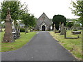
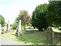
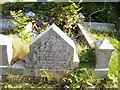
2
Another Chapel, Pembroke Dock Cemetery
Image: © Peter Whatley
Taken: 22 Jul 2009
0.13 miles
4
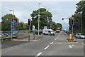
Traffic lights at junction on A477, London Road
Ferry Road, A4139, goes to the right; the white van is leaving Eastern Avenue.
Image: © M J Roscoe
Taken: 30 May 2022
0.17 miles
5
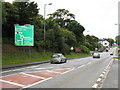
Approach To Waterloo Junctions, Pembroke Dock
The A477 on its final stretch before the port.
Image: © Peter Whatley
Taken: 22 Jul 2009
0.20 miles

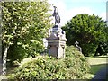
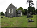
9
Cemetery London Road Pembroke Dock - T H W Idris
Image: © welshbabe
Taken: 8 Sep 2015
0.22 miles
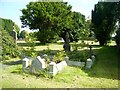
10
Cemetery London Road Pembroke Dock - T H W Idris
Image: © welshbabe
Taken: 8 Sep 2015
0.22 miles