IMAGES TAKEN NEAR TO
Rhoscrowther, PEMBROKE, SA71 5TB
Introduction
This page details the photographs taken nearby to SA71 5TB by members of the Geograph project.
The Geograph project started in 2005 with the aim of publishing, organising and preserving representative images for every square kilometre of Great Britain, Ireland and the Isle of Man.

There are currently over 7.5m images from over14,400 individuals and you can help contribute to the project by visiting https://www.geograph.org.uk
Image Map
Images are licensed for reuse under creativecommons.org/licenses/by-sa/2.0
Notes
- Clicking on the map will re-center to the selected point.
- The higher the marker number, the further away the image location is from the centre of the postcode.
Image Listing (6 Images Found)
Images are licensed for reuse under creativecommons.org/licenses/by-sa/2.0
Image
Details
Distance
1
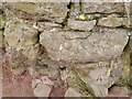
Ordnance Survey Cut Mark
This OS cut mark can be found on the wall at the field gateway. It marks a point 43.818m above mean sea level.
Image: © Adrian Dust
Taken: 30 Mar 2022
0.08 miles
2
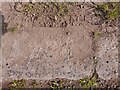
Ordnance Survey Rivet
This OS rivet can be found on the concrete strip running along the NE side of the road. It marks a point 9.787m above mean sea level.
Image: © Adrian Dust
Taken: 30 Mar 2022
0.08 miles
3

Sloe gin, anyone?
A good crop of sloes along the Coast Path
Image: © Eirian Evans
Taken: 1 Sep 2022
0.11 miles
4
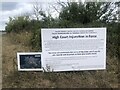
Dire warning notice at Valero Oil Terminal
An injunction against environmental protestors near the Valero Refinery. This follows protests at other sites.
Image: © Eirian Evans
Taken: 1 Sep 2022
0.22 miles
5
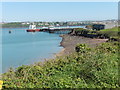
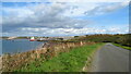
The Pembrokeshire Coast Path near Popton Point
Image: © Dave Kelly
Taken: 8 May 2017
0.23 miles
6
Service road leading to Popton Point & Fort Popton
Image: © Colin Park
Taken: 11 Oct 2022
0.24 miles