IMAGES TAKEN NEAR TO
West Grove Lane, PEMBROKE, SA71 5RP
Introduction
This page details the photographs taken nearby to West Grove Lane, SA71 5RP by members of the Geograph project.
The Geograph project started in 2005 with the aim of publishing, organising and preserving representative images for every square kilometre of Great Britain, Ireland and the Isle of Man.

There are currently over 7.5m images from over14,400 individuals and you can help contribute to the project by visiting https://www.geograph.org.uk
Image Map
Images are licensed for reuse under creativecommons.org/licenses/by-sa/2.0
Notes
- Clicking on the map will re-center to the selected point.
- The higher the marker number, the further away the image location is from the centre of the postcode.
Image Listing (41 Images Found)
Images are licensed for reuse under creativecommons.org/licenses/by-sa/2.0
Image
Details
Distance
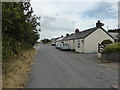
1
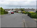
Cricket Grove, Hundleton
A large, modern estate of bungalows.
Image: © Peter Whatley
Taken: 22 Jul 2009
0.10 miles

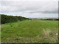
3
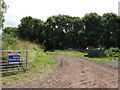
Farmland For Sale
Most of it very wet indeed on the day I visited.
Image: © Peter Whatley
Taken: 22 Jul 2009
0.13 miles

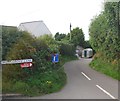
6
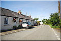
Cottages at Hundleton
A different view to http://www.geograph.org.uk/photo/1415515
Image: © David Medcalf
Taken: 28 Jul 2013
0.14 miles
7
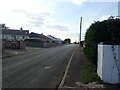
Bungalows on Guilderoy Road, Hundleton
Image: © Eirian Evans
Taken: 31 Aug 2022
0.14 miles