IMAGES TAKEN NEAR TO
Hundleton, PEMBROKE, SA71 5QU
Introduction
This page details the photographs taken nearby to SA71 5QU by members of the Geograph project.
The Geograph project started in 2005 with the aim of publishing, organising and preserving representative images for every square kilometre of Great Britain, Ireland and the Isle of Man.

There are currently over 7.5m images from over14,400 individuals and you can help contribute to the project by visiting https://www.geograph.org.uk
Image Map
Images are licensed for reuse under creativecommons.org/licenses/by-sa/2.0
Notes
- Clicking on the map will re-center to the selected point.
- The higher the marker number, the further away the image location is from the centre of the postcode.
Image Listing (7 Images Found)
Images are licensed for reuse under creativecommons.org/licenses/by-sa/2.0
Image
Details
Distance
1
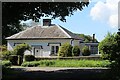
Rose Lodge, Bowett Lane
Attractive early C19 lodge, with flat roof extension on its north side, for the Orielton Estate.
Image: © M J Roscoe
Taken: 2 Sep 2023
0.03 miles

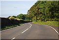
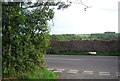
3
Junction of the B4320 and Bowett Lane
Image: © David Medcalf
Taken: 28 Jul 2013
0.14 miles
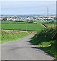
6
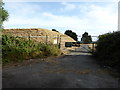
Entrance to the reservoir
WW on the gates stands for Welsh Water, now called Dŵr Cymru.
Image: © David Medcalf
Taken: 28 Jul 2013
0.16 miles