IMAGES TAKEN NEAR TO
Grove Drive, PEMBROKE, SA71 5QB
Introduction
This page details the photographs taken nearby to Grove Drive, SA71 5QB by members of the Geograph project.
The Geograph project started in 2005 with the aim of publishing, organising and preserving representative images for every square kilometre of Great Britain, Ireland and the Isle of Man.

There are currently over 7.5m images from over14,400 individuals and you can help contribute to the project by visiting https://www.geograph.org.uk
Image Map
Images are licensed for reuse under creativecommons.org/licenses/by-sa/2.0
Notes
- Clicking on the map will re-center to the selected point.
- The higher the marker number, the further away the image location is from the centre of the postcode.
Image Listing (14 Images Found)
Images are licensed for reuse under creativecommons.org/licenses/by-sa/2.0
Image
Details
Distance
2
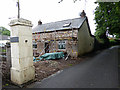
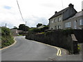
Lodge refurbishment
The lodge is for the historic Underdown House, now a guest house and thought be Cromwell's HQ during the siege of Pembroke Castle.
Image: © John Lucas
Taken: 13 Jul 2015
0.12 miles
3
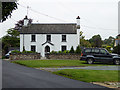
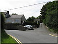
Grove Hall, Pembroke
A somewhat grandly named but attractive traditional style house in Grove Hill.
Image: © John Lucas
Taken: 13 Jul 2015
0.13 miles
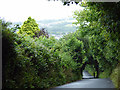
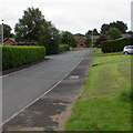
7
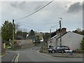
Grove district of Pembroke
At the foot of Grove Hill.
Image: © Alan Hughes
Taken: 23 Apr 2023
0.19 miles
8
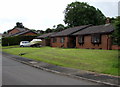
Southlands bungalows, Pembroke
Southlands is a cul-de-sac on the east side of the B4319 St Daniel's Hill.
Image: © Jaggery
Taken: 21 Jul 2015
0.22 miles
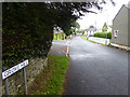
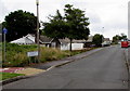
9
Southlands, Pembroke
Cul-de-sac on the east side of the B4319 St Daniel's Hill.
Image: © Jaggery
Taken: 21 Jul 2015
0.22 miles
10
St Daniel's Drive, Pembroke
On the east side of the B4319 St Daniel's Hill.
Image: © Jaggery
Taken: 21 Jul 2015
0.22 miles