IMAGES TAKEN NEAR TO
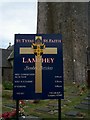
Lamphey, PEMBROKE, SA71 5NR
Introduction
This page details the photographs taken nearby to SA71 5NR by members of the Geograph project.
The Geograph project started in 2005 with the aim of publishing, organising and preserving representative images for every square kilometre of Great Britain, Ireland and the Isle of Man.

There are currently over 7.5m images from over14,400 individuals and you can help contribute to the project by visiting https://www.geograph.org.uk
Image Map (Loading...)


Getting Data...Please wait
Leaflet Map data © OpenStreetMap
Images are licensed for reuse under creativecommons.org/licenses/by-sa/2.0
Notes
- Clicking on the map will re-center to the selected point.
- The higher the marker number, the further away the image location is from the centre of the postcode.
Image Listing (106 Images Found)
Images are licensed for reuse under creativecommons.org/licenses/by-sa/2.0
Image
Details
Distance
1
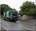
Wheelie bin lorry in Lamphey
Viewed across the A4139. The two wheelie bins on the back of the lorry have just been emptied.
Image: © Jaggery
Taken: 21 Jul 2015
0.01 miles
2
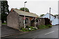
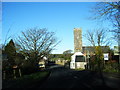
Diamond Jubilee Church Room, Lamphey
The year 1897 (the Diamond Jubilee of Queen Victoria's accession to the throne in 1837)
is inscribed in stone on this building opposite St Faith's church.
Image: © Jaggery
Taken: 21 Jul 2015
0.01 miles
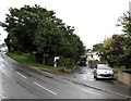
3
A4139 bus shelter, Lamphey
Alongside the A4139, near the SW corner of St Faith's churchyard.
Image: © Jaggery
Taken: 21 Jul 2015
0.02 miles
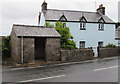
5
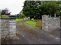
Entrance to The Vicarage, Lamphey
The vicarage is set back 40 metres from the west side of the A4139, opposite St Faith's church.
Image: © Jaggery
Taken: 21 Jul 2015
0.02 miles
6
Access road to Lamphey railway station
From the A4139. Lamphey is a request stop station http://www.geograph.org.uk/photo/4579565 on the single-track section of
the Pembroke Dock branch of the West Wales Line between Manorbier station and Pembroke station.
Image: © Jaggery
Taken: 21 Jul 2015
0.02 miles
7
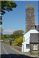
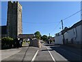
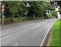
Lamphey
The A4139 passes through the village of Lamphey with two right angle bends crossing the railway and passing the church in the process. Lamphey has a population of just under 300 and is best known for the nearby Bishop's Palace ruins.
Image: © Stephen McKay
Taken: 14 May 2018
0.02 miles
9
Humpback bridge and road narrows signs, Lamphey
Alongside the A4139 on the approach to the bridge over the West Wales Line railway near Lamphey railway station. www.geograph.org.uk/photo/4581318
Image: © Jaggery
Taken: 21 Jul 2015
0.03 miles