IMAGES TAKEN NEAR TO
Freshwater East, PEMBROKE, SA71 5LT
Introduction
This page details the photographs taken nearby to SA71 5LT by members of the Geograph project.
The Geograph project started in 2005 with the aim of publishing, organising and preserving representative images for every square kilometre of Great Britain, Ireland and the Isle of Man.

There are currently over 7.5m images from over14,400 individuals and you can help contribute to the project by visiting https://www.geograph.org.uk
Image Map (Loading...)


Getting Data...Please wait
Leaflet Map data © OpenStreetMap
Images are licensed for reuse under creativecommons.org/licenses/by-sa/2.0
Notes
- Clicking on the map will re-center to the selected point.
- The higher the marker number, the further away the image location is from the centre of the postcode.
Image Listing (9 Images Found)
Images are licensed for reuse under creativecommons.org/licenses/by-sa/2.0
Image
Details
Distance

2
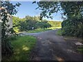
The three-way junction at Thrustle Mill
Image: © David Medcalf
Taken: 9 Aug 2021
0.04 miles
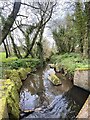
3
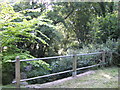
Bridge at Thrustle Mill
A deep valley with an unnamed stream which flows east to Freshwater East.
Image: © Jonathan Billinger
Taken: 9 Aug 2007
0.04 miles
4
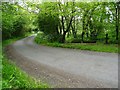
Country road passing Thrustle Mill
Country road in a valley bottom passing Thrustle Mill to the north of the village named either Cheriton or Stackpole Elidor.
Image: © Philip Halling
Taken: 16 May 2019
0.04 miles

9
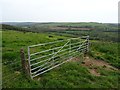
Farmland near Stackpole Elidor
Gate to a field above Thrustle Mill to the north of a village which appears to have two names, Cheriton or Stackpole Elidor.
Image: © Philip Halling
Taken: 16 May 2019
0.25 miles