IMAGES TAKEN NEAR TO
Freshwater East, PEMBROKE, SA71 5LR
Introduction
This page details the photographs taken nearby to SA71 5LR by members of the Geograph project.
The Geograph project started in 2005 with the aim of publishing, organising and preserving representative images for every square kilometre of Great Britain, Ireland and the Isle of Man.

There are currently over 7.5m images from over14,400 individuals and you can help contribute to the project by visiting https://www.geograph.org.uk
Image Map (Loading...)


Getting Data...Please wait
Leaflet Map data © OpenStreetMap
Images are licensed for reuse under creativecommons.org/licenses/by-sa/2.0
Notes
- Clicking on the map will re-center to the selected point.
- The higher the marker number, the further away the image location is from the centre of the postcode.
Image Listing (27 Images Found)
Images are licensed for reuse under creativecommons.org/licenses/by-sa/2.0
Image
Details
Distance
1
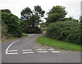
West side of a grass triangle junction in East Trewent
East Trewent is a hamlet in south Pembrokeshire.
Image: © Jaggery
Taken: 21 Jul 2015
0.02 miles
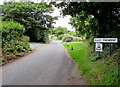
2
Left for Stackpole
The sign is on a grass triangle in East Trewent, a hamlet in south Pembrokeshire.
Image: © Jaggery
Taken: 21 Jul 2015
0.02 miles
3
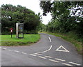
Postbox and BT phonebox, East Trewent
On a grass triangle in East Trewent, a hamlet in south Pembrokeshire.
Image: © Jaggery
Taken: 21 Jul 2015
0.02 miles
4
Southern boundary of East Trewent
Alongside Stackpole Road. East Trewent is a hamlet in south Pembrokeshire.
Below the hamlet name sign, a notice states that this is a HomeWatch Area.
Image: © Jaggery
Taken: 21 Jul 2015
0.04 miles
5
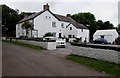
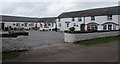
East Trewent Farm Holiday Cottages and B&B
Viewed across Stackpole Road. East Trewent is a hamlet in south Pembrokeshire, in
the Pembrokeshire National Park. East Trewent Farm is near the Pembrokeshire Coastal Path.
Image: © Jaggery
Taken: 21 Jul 2015
0.06 miles
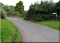
6
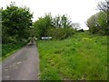
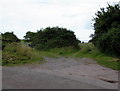
East Trewent
Country road and broad roadside verge at East Trewent.
Image: © Philip Halling
Taken: 16 May 2019
0.07 miles
7
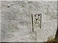
Ordnance Survey Flush Bracket (G5110)
This OS Flush Bracket can be found on a roadside building at East Trewent Farm. It marks a point 59.017m above mean sea level.
Image: © Adrian Dust
Taken: 22 Mar 2022
0.08 miles
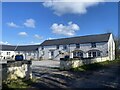
9
East Trewent Farm B&B and Holiday Cottages
Viewed across Stackpole Road. East Trewent is a hamlet in south Pembrokeshire,
in the Pembrokeshire National Park. East Trewent Farm is near the Pembrokeshire Coastal Path.
Image: © Jaggery
Taken: 21 Jul 2015
0.08 miles
10
Two field gates, East Trewent
On the east side of Stackpole Road. East Trewent is a hamlet in south Pembrokeshire.
Image: © Jaggery
Taken: 21 Jul 2015
0.11 miles