IMAGES TAKEN NEAR TO
Crickmarren Close, PEMBROKE, SA71 5LQ
Introduction
This page details the photographs taken nearby to Crickmarren Close, SA71 5LQ by members of the Geograph project.
The Geograph project started in 2005 with the aim of publishing, organising and preserving representative images for every square kilometre of Great Britain, Ireland and the Isle of Man.

There are currently over 7.5m images from over14,400 individuals and you can help contribute to the project by visiting https://www.geograph.org.uk
Image Map (Loading...)


Getting Data...Please wait
Leaflet Map data © OpenStreetMap
Images are licensed for reuse under creativecommons.org/licenses/by-sa/2.0
Notes
- Clicking on the map will re-center to the selected point.
- The higher the marker number, the further away the image location is from the centre of the postcode.
Image Listing (29 Images Found)
Images are licensed for reuse under creativecommons.org/licenses/by-sa/2.0
Image
Details
Distance
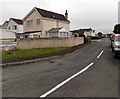
2
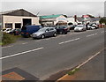
Upper Lamphey Road businesses, Pembroke
In view are a garage and a business selling conservatories, windows, doors etc.
Image: © Jaggery
Taken: 12 Sep 2013
0.08 miles
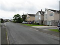
6
Margarets Way Pembroke
On the south side of Upper Lamphey Road, Margarets Way leads to Nicholls Road.
Image: © Jaggery
Taken: 12 Sep 2013
0.09 miles
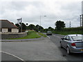
7
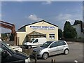
Pembroke Combat Arts
Martial arts centre on Upper Lamphey Road, Pembroke
Image: © Eirian Evans
Taken: 2 Sep 2022
0.09 miles