IMAGES TAKEN NEAR TO
Chapel Lane, PEMBROKE, SA71 5LB
Introduction
This page details the photographs taken nearby to Chapel Lane, SA71 5LB by members of the Geograph project.
The Geograph project started in 2005 with the aim of publishing, organising and preserving representative images for every square kilometre of Great Britain, Ireland and the Isle of Man.

There are currently over 7.5m images from over14,400 individuals and you can help contribute to the project by visiting https://www.geograph.org.uk
Image Map (Loading...)


Getting Data...Please wait
Leaflet Map data © OpenStreetMap
Images are licensed for reuse under creativecommons.org/licenses/by-sa/2.0
Notes
- Clicking on the map will re-center to the selected point.
- The higher the marker number, the further away the image location is from the centre of the postcode.
Image Listing (29 Images Found)
Images are licensed for reuse under creativecommons.org/licenses/by-sa/2.0
Image
Details
Distance
1
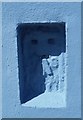
Ordnance Survey Flush Bracket (G5111)
This OS Flush Bracket can be found on Little Portclew Farm. It marks a point 69.800m above mean sea level.
Image: © Adrian Dust
Taken: 27 Apr 2019
0.09 miles
2
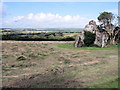
Portclew Chapel (ruin), Freshwater East
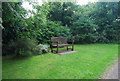
This view to north-east from the corner of the field shows the ruined chapel. This appears to be a 13th Century rebuild of an earlier structure. Recent archaeological excavations near the ruin have provided a radiocarbon date of 550AD, suggesting that the site was in use during the early Christian 'Age of the Saints'.
The field in which the chapel stands is part of biological conservation project involving restoration of traditional hay meadows (7 acres). Hedgerows and small areas of recently planted woodland are also included in order to restore biodiversity.
The view extends from the Old Red Sandstone (ORS) ridge on which the chapel is built to another parallel ridge ('The Ridgeway') also developed on ORS.
The broad vale that separates these ridges is floored by Carboniferous Limestone in the eroded core of the Pembroke Syncline.
Please note that the chapel is on private land managed exclusively for nature conservation. The field gate is always kept locked to avoid accidental release of grazing animals. The ruin is also potentially hazardous.
Should you wish to visit the ruin or the conservation project please call at 'Sea Hollies' or 'Highlands'. These two houses are at the top of Chapel Lane, near to the ruin. Someone will probably be available to show you round (this will be safer and more informative) but if not leave a note with contact telephone number to arrange a viewing.
Image: © Sid Howells
Taken: 21 Apr 2005
0.09 miles
5
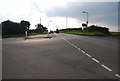
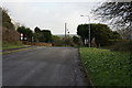
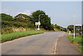
From B road to unclassified road, Freshwater East
Looking east along Portclew Road past the broken lines at the Trewent Hill junction.
On this side, Portclew Road is the B4584. Beyond the dark car, Portclew Road is unclassified.
Image: © Jaggery
Taken: 21 Jul 2015
0.14 miles
7
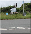
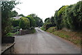
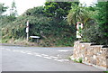
Signs near the eastern start/end of the B4584, Freshwater East
Here named Portclew Road, the B4584 is a short (less than 3km) road in south Pembrokeshire from Lamphey to here in Freshwater East. A few metres east of the signs, roads are unclassified. Viewed from the corner of Trewent Hill.
Image: © Jaggery
Taken: 21 Jul 2015
0.15 miles