IMAGES TAKEN NEAR TO
Upper Lamphey Road, PEMBROKE, SA71 5JS
Introduction
This page details the photographs taken nearby to Upper Lamphey Road, SA71 5JS by members of the Geograph project.
The Geograph project started in 2005 with the aim of publishing, organising and preserving representative images for every square kilometre of Great Britain, Ireland and the Isle of Man.

There are currently over 7.5m images from over14,400 individuals and you can help contribute to the project by visiting https://www.geograph.org.uk
Image Map (Loading...)


Getting Data...Please wait
Leaflet Map data © OpenStreetMap
Images are licensed for reuse under creativecommons.org/licenses/by-sa/2.0
Notes
- Clicking on the map will re-center to the selected point.
- The higher the marker number, the further away the image location is from the centre of the postcode.
Image Listing (15 Images Found)
Images are licensed for reuse under creativecommons.org/licenses/by-sa/2.0
Image
Details
Distance
1
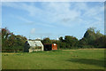
Barn, Lamphey
Beside it is an old railway wagon now used as a farm building.
Image: © JThomas
Taken: 16 Oct 2019
0.12 miles
2
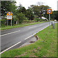
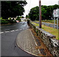
Start of the 30 zone at the western edge of Lamphey
The National Speed Limit along the A4139 from Pembroke drops to 30mph.
Llandyfái is the Welsh name for Lamphey.
Image: © Jaggery
Taken: 21 Jul 2015
0.13 miles
3
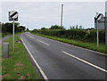
End of the 30 zone at the western edge of Lamphey
The speed limit increases from 30 to the National Speed Limit along the A4139 towards Pembroke.
Image: © Jaggery
Taken: 21 Jul 2015
0.13 miles
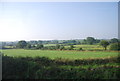
5
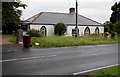
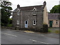
Lamphey Lodge, Lamphey
Single-storey house on the north side of the A4139.
Image: © Jaggery
Taken: 21 Jul 2015
0.18 miles
7
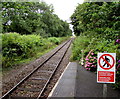
West Wales Line railway towards Pembroke from Lamphey station
A single-track section of the Pembroke Dock branch of the West Wales Line viewed from Lamphey station. http://www.geograph.org.uk/photo/4579565
Image: © Jaggery
Taken: 21 Jul 2015
0.20 miles
8
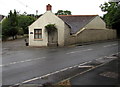
East side of the Longhouse, Lamphey
On the corner of the A4139 and Glebe Cottages.
Image: © Jaggery
Taken: 21 Jul 2015
0.21 miles
9
Road to Pembroke from Lamphey
On the right, the sign pointing west along the A4139 shows that there is 14' 9" headroom bridge 1½ miles ahead.
Image: © Jaggery
Taken: 21 Jul 2015
0.22 miles
10
The Forge, Lamphey
On the south side of the A4139.
Image: © Jaggery
Taken: 21 Jul 2015
0.23 miles