IMAGES TAKEN NEAR TO
Upper Lamphey Road, PEMBROKE, SA71 5JR
Introduction
This page details the photographs taken nearby to Upper Lamphey Road, SA71 5JR by members of the Geograph project.
The Geograph project started in 2005 with the aim of publishing, organising and preserving representative images for every square kilometre of Great Britain, Ireland and the Isle of Man.

There are currently over 7.5m images from over14,400 individuals and you can help contribute to the project by visiting https://www.geograph.org.uk
Image Map
Images are licensed for reuse under creativecommons.org/licenses/by-sa/2.0
Notes
- Clicking on the map will re-center to the selected point.
- The higher the marker number, the further away the image location is from the centre of the postcode.
Image Listing (18 Images Found)
Images are licensed for reuse under creativecommons.org/licenses/by-sa/2.0
Image
Details
Distance
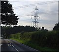
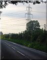
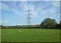
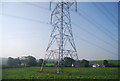
2
A4139 crossed by power lines near Elm Grove
Image: © Colin Pyle
Taken: 10 Dec 2012
0.04 miles
6
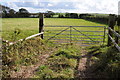
Gateway to a field off the A4139
The railway to Pembroke passes beyond the hedge on the far side of the field.
Image: © Philip Halling
Taken: 17 Sep 2011
0.12 miles
7
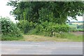
Entrance to Fifth Lane off A4139
Overgrown entrance to overgrown impassable Fifth Lane, a public footpath, between arable fields.
Image: © M J Roscoe
Taken: 24 Jun 2024
0.13 miles
8
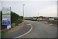
South Meadow Homes
A new housing development.
Image: © N Chadwick
Taken: 27 Aug 2013
0.13 miles
10
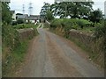
Lamphey Mill Bridge
With Lamphey Mill beyond.
Image: © Jennifer Luther Thomas
Taken: 10 Aug 2006
0.18 miles