IMAGES TAKEN NEAR TO
Castlemartin, PEMBROKE, SA71 5HW
Introduction
This page details the photographs taken nearby to SA71 5HW by members of the Geograph project.
The Geograph project started in 2005 with the aim of publishing, organising and preserving representative images for every square kilometre of Great Britain, Ireland and the Isle of Man.

There are currently over 7.5m images from over14,400 individuals and you can help contribute to the project by visiting https://www.geograph.org.uk
Image Map
Images are licensed for reuse under creativecommons.org/licenses/by-sa/2.0
Notes
- Clicking on the map will re-center to the selected point.
- The higher the marker number, the further away the image location is from the centre of the postcode.
Image Listing (56 Images Found)
Images are licensed for reuse under creativecommons.org/licenses/by-sa/2.0
Image
Details
Distance
2
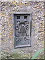
Ordnance Survey Flush Bracket (G5104)
This OS Flush Bracket can be found on a roadside building at Chapel Farm. It marks a point 57.930m above mean sea level.
Image: © Adrian Dust
Taken: 26 May 2014
0.09 miles
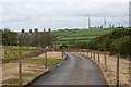
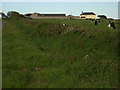
3
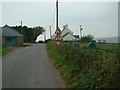
Road near Chapel Farm
The green shelters in the field are for calves which are kept in the enclosure.
Image: © Robin Lucas
Taken: 15 Oct 2009
0.10 miles
6
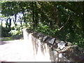
St Michael's Church, Castlemartin - rings in wall - for horses?
Image: © welshbabe
Taken: 31 Aug 2016
0.12 miles
8
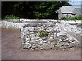
St Michael's Church, Castlemartin - detached mounting block
Image: © welshbabe
Taken: 31 Aug 2016
0.13 miles
9
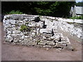
St Michael's Church, Castlemartin - detached mounting block
Image: © welshbabe
Taken: 31 Aug 2016
0.13 miles
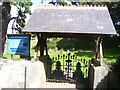
10
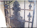
St Michael's Church, Castlemartin - gates
Elaborate gates dated 1890.
Image: © welshbabe
Taken: 31 Aug 2016
0.13 miles