IMAGES TAKEN NEAR TO
Warren, Castlemartin, PEMBROKE, SA71 5HR
Introduction
This page details the photographs taken nearby to SA71 5HR by members of the Geograph project.
The Geograph project started in 2005 with the aim of publishing, organising and preserving representative images for every square kilometre of Great Britain, Ireland and the Isle of Man.

There are currently over 7.5m images from over14,400 individuals and you can help contribute to the project by visiting https://www.geograph.org.uk
Image Map (Loading...)


Getting Data...Please wait
Leaflet Map data © OpenStreetMap
Images are licensed for reuse under creativecommons.org/licenses/by-sa/2.0
Notes
- Clicking on the map will re-center to the selected point.
- The higher the marker number, the further away the image location is from the centre of the postcode.
Image Listing (36 Images Found)
Images are licensed for reuse under creativecommons.org/licenses/by-sa/2.0
Image
Details
Distance
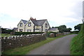
3

Cold Comfort
House on the outskirts of Warren, dating from the early C19th. It is Grade II listed
Image: © Eirian Evans
Taken: 2 Sep 2022
0.03 miles
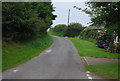
5
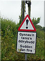
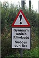
Sudden gunfire sign and there was today
Image: © Steve Fareham
Taken: 13 Jun 2017
0.07 miles
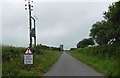
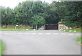
9
Beware!
Close to the Castlemartin Ranges.
Image: © N Chadwick
Taken: 27 Aug 2013
0.11 miles