IMAGES TAKEN NEAR TO
Stackpole, PEMBROKE, SA71 5BU
Introduction
This page details the photographs taken nearby to SA71 5BU by members of the Geograph project.
The Geograph project started in 2005 with the aim of publishing, organising and preserving representative images for every square kilometre of Great Britain, Ireland and the Isle of Man.

There are currently over 7.5m images from over14,400 individuals and you can help contribute to the project by visiting https://www.geograph.org.uk
Image Map
Images are licensed for reuse under creativecommons.org/licenses/by-sa/2.0
Notes
- Clicking on the map will re-center to the selected point.
- The higher the marker number, the further away the image location is from the centre of the postcode.
Image Listing (7 Images Found)
Images are licensed for reuse under creativecommons.org/licenses/by-sa/2.0
Image
Details
Distance
1
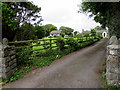
Furzton Cottages south of Pembroke
Set back about 70 metres from the east side of the B4319.
Image: © Jaggery
Taken: 21 Jul 2015
0.01 miles
2
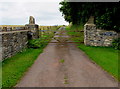
Access road to Woodsend Farm south of Pembroke
From the east side of the B4319.
Image: © Jaggery
Taken: 21 Jul 2015
0.05 miles
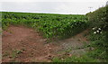
3
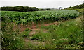
July crop in a field near Furzton Wood
Viewed from this field gate http://www.geograph.org.uk/photo/4581064 in south Pembrokeshire.
Image: © Jaggery
Taken: 21 Jul 2015
0.11 miles
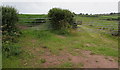
4
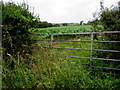
Overgrown area around a field gate near Furzton Wood
Located on the west side of the B4319 in south Pembrokeshire.
The height of the grass and weeds in July 2015 shows that this gate has not been used for some time.
Image: © Jaggery
Taken: 21 Jul 2015
0.12 miles
5
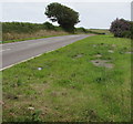
B4319 between Pembroke and St Petrox
In south Pembrokeshire.
Image: © Jaggery
Taken: 21 Jul 2015
0.15 miles
6
Crops in a south Pembrokeshire field
Viewed from the gate on the left here. http://www.geograph.org.uk/photo/4581139
Image: © Jaggery
Taken: 21 Jul 2015
0.22 miles
7
Two field gates south of Pembroke
On the west side of the B4319. Behind the left gate is a field of crops. http://www.geograph.org.uk/photo/4581144
Grazing land and a track http://www.geograph.org.uk/photo/4581154 are behind the right gate.
Image: © Jaggery
Taken: 21 Jul 2015
0.23 miles