IMAGES TAKEN NEAR TO
Angle Village, PEMBROKE, SA71 5AY
Introduction
This page details the photographs taken nearby to Angle Village, SA71 5AY by members of the Geograph project.
The Geograph project started in 2005 with the aim of publishing, organising and preserving representative images for every square kilometre of Great Britain, Ireland and the Isle of Man.

There are currently over 7.5m images from over14,400 individuals and you can help contribute to the project by visiting https://www.geograph.org.uk
Image Map
Images are licensed for reuse under creativecommons.org/licenses/by-sa/2.0
Notes
- Clicking on the map will re-center to the selected point.
- The higher the marker number, the further away the image location is from the centre of the postcode.
Image Listing (165 Images Found)
Images are licensed for reuse under creativecommons.org/licenses/by-sa/2.0
Image
Details
Distance
4
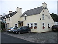
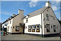
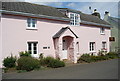
The Hibernia Inn, Angle
At one time there was much trade between here and Ireland, hence the name.
Image: © David Purchase
Taken: 1 Sep 2018
0.06 miles
9
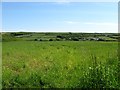
Looking over farmland to the west part of Angle
The geography can clearly be seen: this northern headland is one ridge running WNW-ESE, with the main spine of the peninsula another higher one. The village of Angle occupies most of the valley in between.
Image: © Colin Bell
Taken: 15 Jun 2008
0.08 miles