IMAGES TAKEN NEAR TO
Rhoscrowther, PEMBROKE, SA71 5AG
Introduction
This page details the photographs taken nearby to SA71 5AG by members of the Geograph project.
The Geograph project started in 2005 with the aim of publishing, organising and preserving representative images for every square kilometre of Great Britain, Ireland and the Isle of Man.

There are currently over 7.5m images from over14,400 individuals and you can help contribute to the project by visiting https://www.geograph.org.uk
Image Map (Loading...)


Getting Data...Please wait
Leaflet Map data © OpenStreetMap
Images are licensed for reuse under creativecommons.org/licenses/by-sa/2.0
Notes
- Clicking on the map will re-center to the selected point.
- The higher the marker number, the further away the image location is from the centre of the postcode.
Image Listing (16 Images Found)
Images are licensed for reuse under creativecommons.org/licenses/by-sa/2.0
Image
Details
Distance
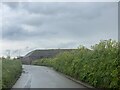
1
Newton Farm, south of Rhoscrowther, Pembrokeshire
Image: © nick macneill
Taken: 7 Sep 2010
0.01 miles
2
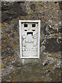
Ordnance Survey Flush Bracket (G5102)
This OS Flush Bracket can be found on the north face on Newton Farm. It marks a point 61.113m above mean sea level.
Image: © Adrian Dust
Taken: 26 May 2014
0.02 miles

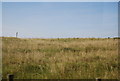
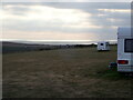
5
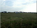
Campers and Caravans near Freshwater West
At Newton Farm Campsite
Image: © Eirian Evans
Taken: 2 Sep 2022
0.06 miles
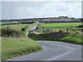
6
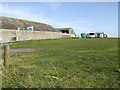
Newton Farm
A site for camping and caravans by the B4320 west of Pembroke.
Image: © Jonathan Billinger
Taken: 9 Aug 2007
0.07 miles
7
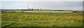
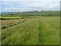
Farmland north of B4320
Milford Haven Oil Refinery in the distance.
Image: © N Chadwick
Taken: 27 Aug 2013
0.13 miles
8
Looking west to the coast from Newton Farm Campsite
Image: © Eirian Evans
Taken: 1 Sep 2022
0.14 miles