IMAGES TAKEN NEAR TO
Pembroke Road, PEMBROKE, SA71 4RJ
Introduction
This page details the photographs taken nearby to Pembroke Road, SA71 4RJ by members of the Geograph project.
The Geograph project started in 2005 with the aim of publishing, organising and preserving representative images for every square kilometre of Great Britain, Ireland and the Isle of Man.

There are currently over 7.5m images from over14,400 individuals and you can help contribute to the project by visiting https://www.geograph.org.uk
Image Map (Loading...)


Getting Data...Please wait
Leaflet Map data © OpenStreetMap
Images are licensed for reuse under creativecommons.org/licenses/by-sa/2.0
Notes
- Clicking on the map will re-center to the selected point.
- The higher the marker number, the further away the image location is from the centre of the postcode.
Image Listing (15 Images Found)
Images are licensed for reuse under creativecommons.org/licenses/by-sa/2.0
Image
Details
Distance
1
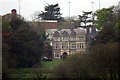
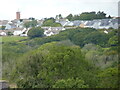
Bush House, Pembroke Road, from Pembroke Castle
The original Bush House may have been erected in the 1660s by Essex Meyrick on the site of a farm or manor house. It was substantially rebuilt by Thomas Charlton Meyrick from about 1839 onwards but on the 8th January 1866, a fire broke out in a chimney and this spread to the main building. The fire was considered worthy of report in the national press and the loss was estimated at £20,000, of which only £4,000 was covered by insurance. The new house was built in 1905 and in 1952-53 Pembrokeshire Education Authority decided that a new Grammar School was required and it purchased the Bush House (Meyrick) estate. The opportunity for an Agricultural Department as part of the new school was established and 6 hectares were transformed into playing fields, 17 hectares became the farming area, a new set of farm buildings were built and Bush House was modernised and adapted as a residential house for boarders. During the Autumn of 1955 Bush House was opened to its first pupils and the agricultural course commenced. In the late 80’s the number of boarders at Bush House decreased for various reasons and it was closed. Due to the increasing costs of running the farm and the gardens, the Department was closed in 1990. It became a residential home for elderly people. In October 2014 the Western Telegraph reported 'Bush House care home has been forced to end nursing care due to a recruitment crisis'.
Image: © Jo and Steve Turner
Taken: 4 May 2008
0.05 miles
2
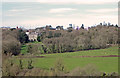
Bush House and Grounds: Pembroke Dock
Bush House was originally the seat of the Meyricks - the main landowners in Pembroke Dock during the 19th century. The surrounding buildings are parts of Pembroke School. Viewed from Pembroke Castle.
Image: © Dylan Moore
Taken: 25 Mar 2017
0.06 miles
3
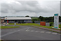
Pembroke Leisure Centre
Swimming, climbing wall, tennis, basket ball and so on. It's larger than it looks! Shared with schools during term time.
Image: © John Horne
Taken: 28 Jun 2007
0.10 miles
6
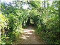
Pembrokeshire Coast Path
Going through woodland near Glan-y-Mor Farm
Image: © Eirian Evans
Taken: 31 Aug 2022
0.15 miles
7
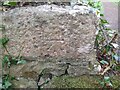
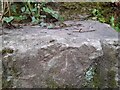
Ordnance Survey Cut Mark
This OS cut mark can be found on the wall west side of the track. It marks a point 17.718m above mean sea level.
Image: © Adrian Dust
Taken: 25 Mar 2022
0.15 miles
8
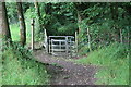
Kissing gate in woodland, Bush
Gate on Pembrokeshire Coastal Path.
Image: © M J Roscoe
Taken: 1 Aug 2023
0.17 miles
9
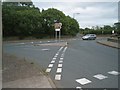
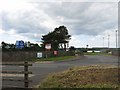
Crossroads on A4139
Looking across to Buttermilk Lane from B4322.
Image: © Jennifer Luther Thomas
Taken: 8 Aug 2006
0.18 miles
10
Ordnance Survey Pivot
This OS pivot can be found on the top step of the stile. It marks a point 18.639m above mean sea level.
Image: © Adrian Dust
Taken: 25 Mar 2022
0.19 miles